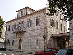
Imotski
| Imotski | |||
|---|---|---|---|
| Town | |||
| Town of Imotski Grad Imotski |
|||

Imotski City Hall
|
|||
|
|||
| Location of Imotski in Croatia | |||
| Coordinates: 43°27′N 17°13′E / 43.450°N 17.217°ECoordinates: 43°27′N 17°13′E / 43.450°N 17.217°E | |||
| Country |
|
||
| County |
|
||
| Government | |||
| • Mayor | Ante Đuzel (HDZ) | ||
| Area | |||
| • Town | 73.25 km2 (28.28 sq mi) | ||
| Elevation | 300 m (1,000 ft) | ||
| Population (2011) | |||
| • Town | 4,757 | ||
| • Urban | 10,764 | ||
| Time zone | CET (UTC+1) | ||
| • Summer (DST) | CEST (UTC+2) | ||
| Postal code | 21260 | ||
| Area code(s) | 021 | ||
| Website | imotski.hr | ||
Imotski (pronounced [ǐmɔtskiː]; Italian: Imoschi; Latin: Emotha, later Imota) is a small town situated on the northern side of Biokovo massif, Dalmatian Hinterland, Croatia. As of 2011[update], the town population is 4,757 and the total municipal population is 10,764. Imotski has a very mild and pleasant climate with many sunny days.
The town is located close to the border with Bosnia-Herzegovina, by the towns of Posušje and Grude. The nearest coastal town is Makarska.
Imotski is known for its medieval fortress on the rocks of Blue Lake. Another phenomenon is the Red Lake which looks like an eye in the scenery. Both lakes are said to be connected with underground channels to the Adriatic Sea.
The town was first mentioned as Imotski in the 10th century. It was held by the Turks from the fall of Bosnia in 1492 until 1717 when it was captured by the Venetians.
Unlike other towns in the area, Imotski had an educational system which consisted of primary and secondary schools from as early as the beginning of the 20th century. The secondary school was founded in 1912 when Imotski was part of the Kingdom of Dalmatia within the Austro-Hungarian empire.
...
Wikipedia


