Industrialnyi District, Dnipropetrovsk
|
Industrialnyi District Індустріальний район |
||
|---|---|---|
| Urban district | ||
|
||
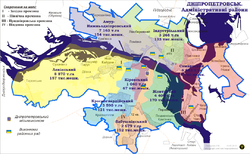
 Map of the urban districts of Dnipropetrovsk. |
||
| Coordinates: 48°31′00″N 35°05′00″E / 48.51667°N 35.08333°ECoordinates: 48°31′00″N 35°05′00″E / 48.51667°N 35.08333°E | ||
| Country |
|
|
| Municipality | Dnipropetrovsk Municipality | |
| Established | 23 May 1969 | |
| Government | ||
| • Chairman of District Council |
Yuriy Dehtyarov | |
| Area | ||
| • Total | 33.033 km2 (12.754 sq mi) | |
| Population (2001 census) | ||
| • Total | 134,425 | |
| • Density | 4,100/km2 (11,000/sq mi) | |
| Time zone | EET (UTC+2) | |
| • Summer (DST) | EEST (UTC+3) | |
| Area code | +380 562 | |
| KOATUU | 1210137200 | |
| Website | www |
|
Industrialnyi District (Ukrainian: Індустріальний район) is an urban district of the city of Dnipropetrovsk, in southern Ukraine. It is located at the northern portion of the city on the left-bank of Dnieper River along with the city's Amur-Nyzhnodniprovskyi District and Samarskyi districts.
The Industrialnyi District was created on 23 May 1969 by splitting away the eastern and northern parts of the Amur-Nyzhnodniprovskyi District that predominantly contain areas of heavy industry.
In 1977 the eastern outskirts of the Industrialnyi District along the Samara River were transferred to the newly formed Samarskyi District. The major factory of the district is the Nyzhnodniprovsk Pipe-rolling Factory that is owned by the Ukrainian Interpipe Group.
...
Wikipedia

