Inverell, New South Wales
|
Inverell New South Wales |
|||||||
|---|---|---|---|---|---|---|---|

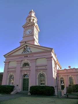
Inverell Court House, built in 1886
|
|||||||
| Coordinates | 29°46′S 151°07′E / 29.767°S 151.117°ECoordinates: 29°46′S 151°07′E / 29.767°S 151.117°E | ||||||
| Population | 16,075 (2011 census) | ||||||
| Established | 1856 | ||||||
| Postcode(s) | 2360 | ||||||
| Elevation | 582 m (1,909 ft) | ||||||
| Location |
|
||||||
| LGA(s) | Inverell Shire | ||||||
| County | Gough | ||||||
| State electorate(s) | Northern Tablelands | ||||||
| Federal Division(s) | New England | ||||||
|
|||||||
Inverell is a town in northern New South Wales, Australia, situated on the Macintyre River. It is also the centre of Inverell Shire. Inverell is located on the Gwydir Highway on the western slopes of the Northern Tablelands. It has a temperate climate. In the 2011 census, the population of Inverell was 9,347.
In 1848, Alexander Campbell held the 50,000-acre (20,000 ha) Inverell Station on the Macintyre River. The name derives from the name of Mr. MacIntyre's estate. The word is of Gaelic origin, and signifies "meeting place of the swans"; from "Inver", a meeting place, and "Ell", a swan. The MacIntyre River and Swanbrook Creek join here. The area was also known as "Green Swamp" in the 1850s. Wheat growers, Colin and Rosanna Ross established a store there in 1853, when he asked that a town be surveyed. In 1858 this was done and in the following years the plan was approved and the first land sale was held. Byron Post Office (open since 1855) was replaced by the Inverell Post Office on 15 September 1859. The municipality was proclaimed in March 1872. The last section of the Inverell branchline, from Delungra to Inverell, was opened on 10 March 1902. The last train ran to Inverell on 22 June 1987, and the Delungra to Inverell section of the line was closed on 2 December 1987. In 1871, the population of Inverell was 509, this increased to 1,212 in 1881. After Federation, the population of Inverell was 1,230 in 1911, and grew to 6,530 (1947) and 8,209 (1961 census).
Diamonds were discovered at Copes Creek in 1875 and were mined at Copeton from 1883-1922. Commercial sapphire mining was commenced in 1919 at Frazers Creek near Inverell. Rich alluvial deposits in streams were worked initially by hand miners but there was little recorded production up until approximately 1960.
The Inverell district is in a fertile agricultural region which produces a wide range of crops, including wheat, barley, oats, sorghum, wine grapes and maize. There are also some mining activities with tin, sapphires, zircons and diamonds (mainly industrial) being found. Inverell is known as the ‘Sapphire City’ because of the sapphires that found throughout the local district, contributing to a major part of Australia's sapphire production.
...
Wikipedia

