Isle au Haut, Maine
| Isle au Haut, Maine | |
|---|---|
| Town | |

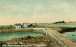
Birch Point and Burnt Island Thoroughfare c. 1908
|
|
 Location in Knox County and the state of Maine. |
|
| Coordinates: 44°3′32″N 68°37′1″W / 44.05889°N 68.61694°WCoordinates: 44°3′32″N 68°37′1″W / 44.05889°N 68.61694°W | |
| Country | United States |
| State | Maine |
| County | Knox |
| Incorporated | 1874 |
| Area | |
| • Total | 113.20 sq mi (293.19 km2) |
| • Land | 12.52 sq mi (32.43 km2) |
| • Water | 100.68 sq mi (260.76 km2) |
| Elevation | 0 ft (0 m) |
| Population (2010) | |
| • Total | 73 |
| • Estimate (2012) | 73 |
| • Density | 5.8/sq mi (2.2/km2) |
| Time zone | Eastern (EST) (UTC-5) |
| • Summer (DST) | EDT (UTC-4) |
| ZIP code | 04645 |
| Area code(s) | 207 Exchange: 335 |
| FIPS code | 23-35135 |
| GNIS feature ID | 0582530 |
Isle au Haut (/ˈaɪ.lə.hoʊ/) is a town in Knox County, Maine, United States, on an island of the same name in Penobscot Bay. The population was 73 at the 2010 census. Home to portions of Acadia National Park, Isle au Haut is accessible by ferry from Stonington, Maine.
Native Americans left behind shell mounds on the island following their oyster feasts. It was territory of the Penobscot Abenaki Indians when, in 1604, French explorer Samuel de Champlain named it Isle au Haut, meaning High Island. English Capt. John Smith, charting the coast in 1614, noted that it was the highest island in Penobscot Bay. It was included in Deer Isle Plantation, incorporated by Massachusetts on February 2, 1789, as the town of Deer Isle.
...
Wikipedia
