Jefferson, Texas
| Jeffersan, Texas | |
|---|---|
| City | |

|
|
 Location of Jefferson, Texas |
|
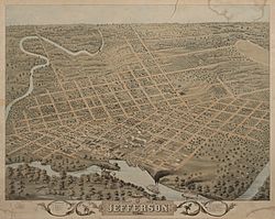
 Map of the city in 1872 |
|
| Coordinates: 32°45′40″N 94°20′58″W / 32.76111°N 94.34944°WCoordinates: 32°45′40″N 94°20′58″W / 32.76111°N 94.34944°W | |
| Country | United States |
| State | Texas |
| County | Marion |
| Area | |
| • Total | 4.4 sq mi (11.4 km2) |
| • Land | 4.3 sq mi (11.3 km2) |
| • Water | 0.1 sq mi (0.2 km2) |
| Elevation | 194 ft (59 m) |
| Population (2000) | |
| • Total | 2,024 |
| • Density | 465.7/sq mi (179.8/km2) |
| Time zone | Central (CST) (UTC-6) |
| • Summer (DST) | CDT (UTC-5) |
| ZIP code | 75657 |
| Area code(s) | 903 |
| FIPS code | 48-37528 |
| GNIS feature ID | 1338692 |
| Website | City of Jefferson |
Jefferson is a historic city in Marion County in northeastern Texas, United States. The population was 2,024 at the 2000 census. It is the county seat of Marion County, Texas, and is situated in East Texas. The city is a tourism center, with popular attractions including: Jay Gould's Railroad car, the Sterne Fountain, Jefferson Carnegie Library, Excelsior House, the House of the Four Seasons, and the bayous formed by Big Cypress Bayou located in and around the city.
Tourism in Jefferson is enhanced by a number of events that are held throughout the year. Major annual events include:
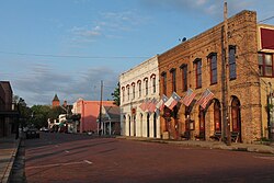
Almost every commercial building and house on the main arterial road in Jefferson has a historic marker.
The Sterne Fountain was given to the city in 1913 to honor the contribution of Jacob and Ernestine Sterne, a Jewish couple who settled in Jefferson before the Civil War and became prominent citizens who managed the post office and were involved in numerous civic and cultural projects. The fountain includes a statue of Hebe, the Greek goddess of Youth, by Giuseppe Moretti.
Early records indicate that Jefferson was founded around 1841 on land ceded from the Caddo Indians. At that time, a log jam more than 100 miles long existed on the Red River north of present , Louisiana. The Indians said that this log jam, known as the Great Red River Raft, had always existed.
The Red River Raft (or Great Raft) acted as a dam on the river and raised the level of Caddo Lake and the Red River several feet. This rise of Caddo Lake and the corresponding rise in the Big Cypress Bayou at Jefferson permitted commercial riverboat travel to Jefferson from ports such as St. Louis and New Orleans via the Mississippi and Red Rivers.
...
Wikipedia

