Jisr ash-Shugour
|
Jisr ash-Shugur جسر الشغور (also romanized as Jisr al-Shughour) |
|
|---|---|

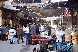
Covered market in the old town of Jisr ash-Shugur (2009)
|
|
| Nickname(s): literally, "bridge of vacancy" | |
| Location in Syria | |
| Coordinates: 35°48′51″N 36°19′12″E / 35.81417°N 36.32000°ECoordinates: 35°48′51″N 36°19′12″E / 35.81417°N 36.32000°E | |
| Country |
|
| Governorate | Idlib Governorate |
| District | Jisr ash-Shugur District |
| Occupation | |
| Elevation | 170 m (560 ft) |
| Population | |
| • Total | 44,322 |
Jisr ash-Shugur (Arabic: جسر الشغور, pronounced [dʒɪsr aʃˈʃuɣuːr]; also spelled Jisr al-Shughour) is a city in the Idlib Governorate in northwestern Syria. Situated at an altitude of 170 metres (560 ft) above sea level on the Orontes river, the city was inhabited by 44,322 people in 2010.
Jisr ash-Shugur has long been an important stopping point on trade routes and is situated on the main route between Latakia, 75 kilometres (47 mi) to the west and Aleppo 104 kilometres (65 mi) to the east. Located in the rich alluvial plain of the Ghab valley on the eastern side of the An-Nusayriyah Mountains (also known as the Jebel Ansariye), the area has been continuously inhabited for over 10,000 years. The ancient city of Qarqar is thought to have been situated some 7 kilometres (4.3 mi) south of the modern town, which was established in Hellenistic times as the city of Seleucia ad Belum. The Romans called it Niaccuba and built a stone bridge there across the Orontes.
Little remains of the ancient city other than portions of the much-repaired Roman bridge, which is now incorporated into a 15th-century Mameluke construction that still serves as one of the city's two bridges over the river. The bridge's V-shaped design was intended to enable it to withstand the force of the river's current. Although Jisr ash-Shugur is mostly of modern construction, a number of old Ottoman-era buildings still survive including a caravanserai built in the centre of the old town between 1660–75 and restored in 1826-27.
...
Wikipedia

