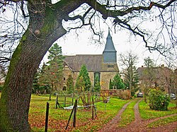
Kötzschau
| Kötzschau | ||
|---|---|---|
| Stadtteil of Leuna | ||

Kötzschau church
|
||
|
||
| Coordinates: 51°18′45″N 12°7′56″E / 51.31250°N 12.13222°ECoordinates: 51°18′45″N 12°7′56″E / 51.31250°N 12.13222°E | ||
| Country | Germany | |
| State | Saxony-Anhalt | |
| District | Saalekreis | |
| Town | Leuna | |
| Area | ||
| • Total | 16.77 km2 (6.47 sq mi) | |
| Elevation | 114 m (374 ft) | |
| Population (2006-12-31) | ||
| • Total | 1,986 | |
| • Density | 120/km2 (310/sq mi) | |
| Time zone | CET/CEST (UTC+1/+2) | |
| Postal codes | 06231 | |
| Dialling codes | 03462 | |
| Vehicle registration | SK | |
| Website | Kötzschau at the Leuna website | |
Kötzschau is a village and a former municipality in the district Saalekreis, in Saxony-Anhalt, Germany. Today, it is a part of Leuna. Kötzschau is situated approximately 11 km southeast of Merseburg and has a population close to 2,000.
Kötzschau is located to the extreme southeast of the municipality of Leuna, and to the east of Saalekreis district and of Saxony-Anhalt. It borders directly on Markranstädt, Saxony. The Saale passes to the west. The brook Bach flows from the southeast to the northwest through Kötzschau. At Schladebach, it is dammed to form the Speicher Schladebach.
Kötzschau consists of the Ortsteile Kötzschau, Rampitz, Schladebach, Thalschütz and Witzschersdorf.
Kötzschau had its first documentary mention in 1205 (Schladebach 1012, Thalschütz 1225, Witzschersdorf 1285, Rampitz 1479). For several centuries, Kötzschau was notable mainly for the presence of a local brine spring and the use of a Saline (which in German refers to a structure employed in the boiling of brine, not to salt evaporation ponds). These were first described in the early 14th century. In 1347, during the war between the Margrave of Meissen and the Archbishop of Magdeburg, Otto von Hessen, the Saline was burned down. It was subsequently rebuilt by the Elector of Saxony.
...
Wikipedia


