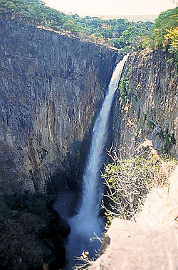
Kalambo Falls
| Kalambo Falls | |
|---|---|
 |
|
| Location | Zambia |
| Coordinates | 8°35′51″S 31°14′23″E / 8.5974°S 31.2396°ECoordinates: 8°35′51″S 31°14′23″E / 8.5974°S 31.2396°E |
The Kalambo Falls on the Kalambo River is a 772ft (235m) single drop waterfall on the border of Zambia and Tanzania at the southeast end of Lake Tanganyika. The falls are some of the tallest uninterrupted falls in Africa (after South Africa's Tugela Falls, Ethiopia's Jin Bahir Falls and others). Downstream of the falls, is the Kalambo Gorge which has a width of about 1km and a depth of up to 300m, running for about 5km before opening out into the Lake Tanganyika rift valley.
The falls were first seen by non-Africans in approximately 1913. Initially it was assumed that the height of falls exceeded 300m, but measurements in the 1920s gave a more modest result, above 200m. Later measurements, in 1956, gave a result of 221m. After this several more measurements have been made, each with slightly different results. The width of the falls is 3.6 – 18m.
Kalambo Falls is also considered one of the most important archaeological sites in Africa, with occupation spanning over 250,000 years.
Archaeologically, Kalambo Falls is one of the most important sites in Africa. It has produced a sequence of past human activity stretching over more than two hundred and fifty thousand years, with evidence of continuous habitation since the Late Early Stone Age until modern times. It was first excavated in 1953 by John Desmond (J.D.) Clark who recognized archaeological activity around a small basin lake upstream of the falls. Excavations in 1953, 1956, 1959, and 1963 allowed Clark to make conclusions about the multiple different cultures inhabiting the area over thousands of years of time.
J.D. Clark's work incorporated both questions of the cultures who lived at the Kalambo Falls site as well as what their environment was like during times of occupation. Using plant (floral) and pollen analyses, Clark was able to conduct the process of paleoenvironmental reconstruction. By studying pollen that settled on the earth during different environmental settings, Clark was able to form a general idea of what ecological factors affected the Kalambo Falls region at different times. In order to do this, Clark used a tool for drawing out sediment cores in order to observe and analyse the different layers below the surface of the earth today. He separated these layers into 6 different spectra, labeled zones U through Z. The law of superposition is important to note when discussing sedimentary layers; this law states that more recent layers of soil dispersal will overlie older ones.
...
Wikipedia

