Kapıkule
| Kapıkule | |
|---|---|

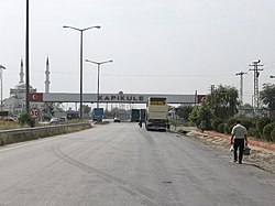
Border crossing on the Turkish side
|
|
| Location of Kapıkule in Turkey | |
| Coordinates: 41°42′28.6″N 26°23′31.1″E / 41.707944°N 26.391972°ECoordinates: 41°42′28.6″N 26°23′31.1″E / 41.707944°N 26.391972°E | |
| Country |
|
| Region | Marmara Region |
| Province | Edirne |
| District | Edirne (Merkez) |
| Time zone | EET (UTC+2) |
| • Summer (DST) | EEST (UTC+3) |
| Postal code | 22xxx |
| Area code(s) | +(90)284 |
Kapıkule is the name of the Turkish border crossing point in Edirne Province on the border of Turkey and Bulgaria. Its counterpart on the Bulgarian side is Kapitan Andreevo. Together, they form the second busiest land border crossing point in the world and the busiest in Europe.
Kapıkule, situated on the State road D100 (D.100) and European route E80, is also an important gateway for cargo transport to the countries east of Turkey. The Asian Highway Network route AH1 terminates at the border. Other land border checkpoints in western Turkey are the neighboring Hamzabeyli (on the D.535) and Dereköy (on the D.555) to Bulgaria and İpsala (on the D.110, E84) to Greece. The Kapıkule railway station, built in 1971, is located to the north of the town and handles more traffic than any other railway border crossing in Turkey.
In the dawn of the Revolutions of 1989, the Kapıkule border crossing saw a mass exodus of Turks fleeing the forced assimilation laws of the mid to late 1980s in the People's Republic of Bulgaria into Turkey.
Around 400.000 vehicles and 4 million people cross annually the border in Kapıkule that makes 35% of all the vehicle and 42% of all the passenger traffic passing through the land borders of Turkey. To meet the demand resulting from growing international crossings, the Union of Chambers and Commodity Exchanges of Turkey (TOBB) signed an agreement with the government in August 2007 to completely overhaul the facilities on Build-Operate-Transfer basis at a cost of 132 million TRL (US$100 million in 2007) in exchange for twenty-year operation.
...
Wikipedia

