Kaweah River
| Kaweah River | |
| River | |
|
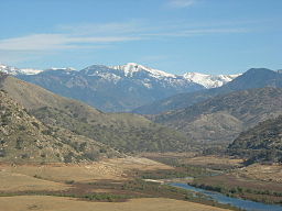
The Kaweah River just below the confluence of its forks, flowing through the drained Lake Kaweah bed (note the light brown "bathtub ring" on the valley slopes). This segment of the river is routinely submerged during high water in the springtime but is usually above the water.
|
|
| Name origin: Yokut for "crow" or "raven cry" | |
| Country | United States |
|---|---|
| State | California |
| County | Tulare County |
| Source | Sierra Nevada Range |
| - location | Sequoia National Park, California |
| - coordinates | 36°30′53″N 118°48′7″W / 36.51472°N 118.80194°W |
| Mouth | San Joaquin Valley |
| - location | Near Visalia, California |
| - coordinates | 36°20′12″N 119°13′23″W / 36.33667°N 119.22306°WCoordinates: 36°20′12″N 119°13′23″W / 36.33667°N 119.22306°W |
| Length | 58.5 mi (94 km) |
| Basin | 828 sq mi (2,145 km2) |
| Discharge | for near Three Rivers, CA |
| - average | 554 cu ft/s (16 m3/s) |
| - max | 80,700 cu ft/s (2,285 m3/s) |
| - min | 20 cu ft/s (1 m3/s) |
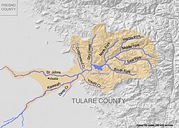
The Kaweah River (/kəˈwijə/) is an approximately 58.5-mile (94.1 km)-long river in the U.S. state of California. It rises in four major forks in the Sierra Nevada within Sequoia National Park, flowing southwest through the Lake Kaweah reservoir and onto an alluvial plain northeast of Visalia. Formerly the river continued southwest to empty into Tulare Lake, the terminal sink of an endorheic basin in the southern Central Valley. However, the river is heavily diverted for irrigation water, and its lower reaches are dry for most of the year.
The foothills of the Sierra around the Kaweah River were once inhabited by the Yokuts people. The name "Kaweah" is thought to mean "crow" or "raven cry" in the Yokuts language. Shoshonean people from the Great Basin later settled in the high valleys of the Kaweah's forks. In the 1870s, a short-lived silver boom took place in the Mineral King valley of the river's East Fork, attracting settlers to the region. The majority of the Kaweah's headwaters above the Central Valley became part of Sequoia National Park in 1890. The southeastern part of the river's watershed also became part of the park in the 1970s after a failed proposal for a massive ski resort. The Kaweah River is now a popular destination for hiking, fishing and whitewater rafting.
...
Wikipedia


