Kendal
Kendal
|
|
|---|---|
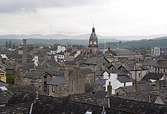
 View over the rooftops of Kendal |
|
| Kendal shown within Cumbria | |
| Population | 28,586 (2011) |
| OS grid reference | SD5192 |
| • London | 223 miles (358.9 km) SSE |
| Civil parish |
|
| District | |
| Shire county | |
| Region | |
| Country | England |
| Sovereign state | United Kingdom |
| Post town | KENDAL |
| Postcode district | LA9 |
| Dialling code | 01539 |
| Police | Cumbria |
| Fire | Cumbria |
| Ambulance | North West |
| EU Parliament | North West England |
| UK Parliament | |
Kendal /ˈkɛndəl/, anciently known as Kirkby in Kendal or Kirkby Kendal, is a market town and civil parish within the South Lakeland District of Cumbria, England. Historically in Westmorland, it is situated about 8 miles (13 km) south-east of Windermere, 19 miles (31 km) north of Lancaster, 23 miles (37 km) north-east of Barrow-in-Furness and 38 miles (61 km) north-west of Skipton. The town lies in the valley or "dale" of the River Kent, from which it derives its name, and has a total resident population of 28,586, making it the third largest settlement in Cumbria behind Carlisle and Barrow-in-Furness.
Kendal today is known largely as a centre for tourism, as the home of Kendal mint cake, and as a producer of pipe tobacco and tobacco snuff. Its buildings, mostly constructed with the local grey limestone, have earned it the nickname Grey Auld Town.
Kendal is listed in the Domesday Book as part of Yorkshire with the name Cherchebi. For many centuries it was called Kirkbie Kendal, meaning "village with a church in the valley of the River Kent". The earliest castle was a Norman motte and bailey (now located on the west side of the town) when the settlement went under the name of Kirkbie Strickland.
...
Wikipedia

