Khulda
| Khulda | |
|---|---|

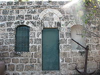
The largest remaining house in Khulda
|
|
| Arabic | خُلدة |
| Name meaning | "the perpetual" |
| Also spelled | Khuldeh |
| Subdistrict | Ramle |
| Coordinates | 31°49′10″N 34°54′14″E / 31.81944°N 34.90389°ECoordinates: 31°49′10″N 34°54′14″E / 31.81944°N 34.90389°E |
| Palestine grid | 141/136 |
| Population | 280 (1945) |
| Area | 9,461 dunams |
| Date of depopulation | April 6, 1948 |
| Cause(s) of depopulation | Military assault by Yishuv forces |
| Current localities | Mishmar David |
Khulda (Arabic: خُلدة), also Khuldeh, was a Palestinian Arab village located 12 kilometers (7.5 mi) south of Ramla in the Mandatory Palestine. Known as Huldre to the Crusaders, it is also mentioned in documents dating to the periods of Mamluk, Ottoman, and Mandatory rule over Palestine. During the 1948 war, the village was depopulated as part of Operation Nachshon and was subsequently destroyed. The Israeli kibbutz of Mishmar David was established that same year on land belonging to the village.
Khulda lay close to a highway connecting Gaza to the Ramla-Jerusalem highway. During the Crusades, the village was known as Huldre. Situated 10 kilometers (6.2 mi) west-south-west of Imwas, prior to the 12th century CE, it lay on the border between the Greek archbishopric of Lydda and the ecclesiastical division of Emmaus, the latter of which was governed directly by archpriest of the Patriarch of Jerusalem.
During the period of Mamluk rule over Palestine, Mujir al-Din al-'Ulaymi narrates how the under-Governor of Ramleh in 1495 had to take refuge against marauding Bedouin in a small fort which then existed at Khulda.
Khulda, like the rest of Palestine, was incorporated into the Ottoman Empire in 1517 and in 1596, it formed part of the nahiya ("subdistrict") of Ramla, in the liwa of Gaza. The village paid taxes on wheat, barley, beehives, and goats, and had a population of sixty-six.
...
Wikipedia

