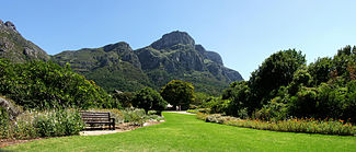
Kirstenbosch
| Kirstenbosch National Botanical Garden | |
|---|---|
 |
|
| Type | Botanical garden |
| Location | Cape Town, South Africa |
| Coordinates | 33°59′22″S 18°25′49″E / 33.98944°S 18.43028°ECoordinates: 33°59′22″S 18°25′49″E / 33.98944°S 18.43028°E |
| Area | 528 hectares (1,300 acres) |
| Created | 1913 |
| Operated by | South African National Biodiversity Institute (SANBI) |
| Website | www |
Kirstenbosch is an important botanical garden nestled at the eastern foot of Table Mountain in Cape Town. The garden is one of nine National Botanical Gardens covering five of South Africa's six different biomes and administered by the South African National Biodiversity Institute (SANBI). Prior to 1 September 2004, the institute was known as the National Botanical Institute.
When Kirstenbosch, the most famous of the gardens, was founded in 1913 to preserve the country's unique flora, it was the first botanical garden in the world with this ethos. Kirstenbosch places a strong emphasis on the cultivation of indigenous plants.
The garden includes a large conservatory (The Botanical Society Conservatory) exhibiting plants from a number of different regions, including savanna, fynbos, karoo and others. Outdoors, the focus is on plants native to the Cape region, highlighted by the spectacular collections of proteas. Kirstenbosch enjoys great popularity with residents and visitors. From the gardens several trails lead off along and up the mountain slopes and these are much used by walkers and mountaineers. One of the trails, up a ravine called Skeleton Gorge, is an easy and popular route to the summit of Table Mountain. This route is also known as Smuts' Track after Prime Minister Jan Smuts who used this route regularly. On the slopes above the cultivated parts of the garden a contour path leads through forests to Constantia Nek to the south. The same contour path can be followed to the north for many kilometres and it will take the hiker past the Rhodes Memorial to the slopes of Devil's Peak and beyond.
...
Wikipedia
