Klarälven
| Klarälven | |
| River | |
|
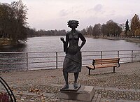
Sola i Karlstad statue
|
|
| Countries | Sweden, Norway |
|---|---|
| Source | Rogen and Femund |
| Mouth | Vänern |
| - location | Karlstad |
| - elevation | 44 m (144 ft) |
| - coordinates | 59°23′19″N 13°29′54″E / 59.38861°N 13.49833°ECoordinates: 59°23′19″N 13°29′54″E / 59.38861°N 13.49833°E |
| Length | 460 km (286 mi) |
| Basin | 11,820 km2 (4,564 sq mi) |
| Discharge | |
| - average | 165 m3/s (5,827 cu ft/s) |
| - max | 1,650 m3/s (58,269 cu ft/s) |
|
Map showing the main lakes connected to Klarälven, as well as its closest major towns.
|
|
Klarälven ("The clear river" in Swedish) is a river flowing through Norway and Sweden. Together with Göta älv, which it is called as the river has passed through the lake Vänern, thus regarded as an entity, Göta älv-Klarälven is the longest river in Scandinavia and in the Nordic countries and its Swedish part the longest river of Sweden. These two rivers also have the largest drainage basin in the same areas, 50,229 km2 (included all the rivers that run into the lake Vänern), of which 42,468 km2 is located in Sweden, and the rest 7,761 in Norway.
It emanates from Lake Rogen in Härjedalen, Sweden, and then passes through the Norwegian Hedmark, where it flows through the lake Femunden. There it is known as Femundelva and Trysilelva (before the nationalistic movement in the 19th century the river was called Klara even in Norway; today it is called Femundelva in the municipality of Engerdal and Trysilelva in the municipality of Trysil, reflecting strong local patriotism in Norway). The rest of the river, the longest part, flows through Värmland to ultimately discharge in a delta into Vänern at Karlstad.
In its turn, Vänern drains then into Göta älv, reaching the sea at Gothenburg.
The river has historically provided significant economic benefits, providing a suitable transport route for log driving, and currently is internationally recognized as excellent sport fishing waters.
...
Wikipedia


