Krasnohvardiiskyi District, Dnipropetrovsk
|
Chechelivskyi District Чечелівський |
||
|---|---|---|
| Urban district | ||

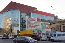
A shopping mall in Chechelivskyi District
|
||
|
||
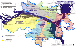
 Map of the urban districts of Dnipropetrovsk. |
||
| Coordinates: 48°25′16″N 34°58′01″E / 48.42111°N 34.96694°ECoordinates: 48°25′16″N 34°58′01″E / 48.42111°N 34.96694°E | ||
| Country |
|
|
| Municipality | Dnipropetrovsk Municipality | |
| Established | 1897 (1932) | |
| Government | ||
| • Chairman of District Council |
Ivan Zahora | |
| Population (2001 census) | ||
| • Total | 120,706 | |
| Time zone | EET (UTC+2) | |
| • Summer (DST) | EEST (UTC+3) | |
| Area code | +380 562 | |
| KOATUU | 1210137800 | |
Chechelivskyi District (Ukrainian: Чечелівський район) is an urban district of the city of Dnipropetrovsk, in southern Ukraine. It is located in the city's center on the southwestern outskirts and the right-bank of the Dnieper River.
It was known as the 5th court district of Yekaterinoslav (Dnipropetrovsk's former name) when it was first created on 1 December 1897. After the 1905 revolution, the district was renamed into the Zavodskyi District and in 1917 the Brianskyi District after the same Briansk Factory (today, Petrovsky Metallurgical Factory of Dnipropetrovsk).
From 1920 to 1923 the district was named the Fabrychno-Chechelivskyi District. In 1923 its name was changed again, this time to the Chechelivskyi District. In 1925 it became known as the Krasnohvardiiskyi District.
In 1963 the eastern portions of the district were annexed to the newly formed Zhovtnevyi District. In 1973 some additional territories of the Zhovtnevyi and Krasnohvardiiskyi districts were also annexed to the newly formed Babushkinskyi District.
November 26, 2015 the order of Acting Mayor within to comply with decommunisation Krasnogvardejskiy District was renamed to Chechelivsky.
...
Wikipedia

