Kyichu
| Lhasa River | |
|---|---|

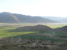
Lhasa River near Ganden Monastery 1 (December 2006)
|
|

|
|
| Etymology | River of Felicity |
| Country | Tibet |
| Physical characteristics | |
| Main source |
Nyenchen Tanglha Mountains 5,290 m (17,360 ft) 30°11′12″N 91°20′41″E / 30.1868°N 91.3448°E |
| River mouth | 3,590 m (11,780 ft) 29°20′27″N 90°45′38″E / 29.34083°N 90.76056°ECoordinates: 29°20′27″N 90°45′38″E / 29.34083°N 90.76056°E |
| Length | 450 km (280 mi) |
| Discharge |
|
| Basin features | |
| River system | Brahmaputra River |
| Basin size | 26,000 km2 (10,000 sq mi) |
| Tributaries | |
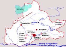
The Lhasa River, also called Kyi River (Tibetan: སྐྱིད་ཆུ་, Wylie: sKyid chu, Chinese: 拉薩河; pinyin: Lāsà hé), is a northern tributary of the Yarlung Tsangpo River in the south of the Tibet Autonomous Region of China. The Yarlung Tsangpo is the upper section of the Brahmaputra River. The Lhasa River is subject to flooding with the summer monsoon rains, and structures have been built to control the floods. In its lower reaches the river valley is an important agricultural area. The city of Lhasa, named after the river, lies on the river. There are two large hydroelectric power stations on the river, the Zhikong Hydro Power Station (100 MW) and the Pangduo Hydro Power Station (160 MW)
The Lhasa River drains an area of 32,471 square kilometres (12,537 sq mi), and is the largest tributary of the middle section of the Yaluzangbu River. The average altitude of the basin is around 4,500 metres (14,800 ft). The basin has complex geology and is tectonically active. Earthquakes are common. The river basin is the center of Tibet politically, economically and culturally. As of 1990 the population was 329,700, of whom 208,700 were farmers. 88% of the people were ethnic Tibetans.
The climate is semi-arid monsoon, with a low average temperature of 1.2 to 7.5 °C (34.2 to 45.5 °F). Average annual precipitation is 466.3 millimetres (18.36 in), with 85% falling in the June-September period. Annual runoff is 10,550,000,000 cubic metres (3.73×10¹¹ cu ft). Water quality is good, with little discharge of sewage and minimal chemical pesticides and fertilizers. The basin has about 35,258 hectares (87,120 acres) of farmland, of which 17,710 hectares (43,800 acres) is irrigated. There are 1,850,000 hectares (4,600,000 acres) of grasslands that may be used for pasturage, and 100,000 hectares (250,000 acres) of forest.
...
Wikipedia
