L'Escale
| L'Escale | ||
|---|---|---|
| Commune | ||

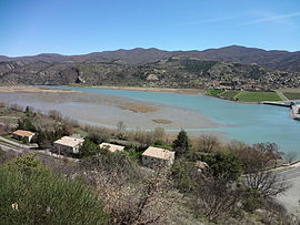
L'Escale Lake as viewed from Château-Arnoux-Saint-Auban.
|
||
|
||
| Coordinates: 44°05′10″N 6°01′25″E / 44.0861°N 6.0236°ECoordinates: 44°05′10″N 6°01′25″E / 44.0861°N 6.0236°E | ||
| Country | France | |
| Region | Provence-Alpes-Côte d'Azur | |
| Department | Alpes-de-Haute-Provence | |
| Arrondissement | Forcalquier | |
| Canton | Château-Arnoux-Saint-Auban | |
| Intercommunality | Moyenne Durance | |
| Government | ||
| • Mayor (2008–2014) | Claude Fiaert | |
| Area1 | 20.36 km2 (7.86 sq mi) | |
| Population (2008)2 | 1,255 | |
| • Density | 62/km2 (160/sq mi) | |
| Time zone | CET (UTC+1) | |
| • Summer (DST) | CEST (UTC+2) | |
| INSEE/Postal code | 04079 /04160 | |
| Elevation | 408–1,081 m (1,339–3,547 ft) (avg. 475 m or 1,558 ft) |
|
|
1 French Land Register data, which excludes lakes, ponds, glaciers > 1 km² (0.386 sq mi or 247 acres) and river estuaries. 2Population without double counting: residents of multiple communes (e.g., students and military personnel) only counted once. |
||
1 French Land Register data, which excludes lakes, ponds, glaciers > 1 km² (0.386 sq mi or 247 acres) and river estuaries.
L'Escale is a commune in the Alpes-de-Haute-Provence department in southeastern France. It is located on the eastern bank of the Durance opposite Château-Arnoux-Saint-Auban.
The Bléone forms the commune's southern border, then flows into the Durance, which forms the commune's western border.
Work began on the dam in 1959 being completed in 1963. With a height of 30ms it retains 15.70 hm³ of water. It is 126 metres long with a road carriageway along which runs the Route Napoleon. There is attached to the dam a power station whose three units produce a total of 170,000 KWs of electricity.
...
Wikipedia


