Lézarde
| Lézarde | |
|---|---|

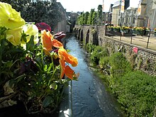
The Lézarde in Montivilliers
|
|
| Country | France |
| Basin features | |
| Main source |
Pays de Caux 106 m (348 ft) |
| River mouth | Seine |
| Progression | Seine→ English Channel |
| Basin size | 116 km2 (45 sq mi) |
| Physical characteristics | |
| Length | 14.2 km (8.8 mi) |
| Discharge |
|
The river Lézarde is one of the rivers that flow from the plateau of the southern Pays de Caux in the Seine-Maritime département of Normandy into the Seine.
The river rises at Saint-Martin-du-Bec and passes Notre-Dame-du-Bec, Rolleville, Épouville, Montivilliers and joins the Seine at Harfleur.
In the past, the river was host to many watermills that powered machinery to process both wheat and oil.
Coordinates: 49°30′N 0°12′E / 49.500°N 0.200°E
...
Wikipedia
