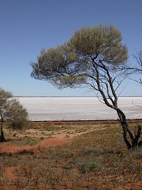
Lake Eyre basin
| Lake Eyre basin | |
| Region | |
|
Lake Hart is one of the smaller lakes in the basin
|
|
| Name origin: Lake Eyre; Edward John Eyre | |
| Country | Australia |
|---|---|
| States and territories |
Queensland, South Australia, Northern Territory, New South Wales |
| Landmarks |
Sturt Stony Desert, Tirari Desert, Strzelecki Desert, Lake Eyre, Lake Frome, Lake Yamma Yamma |
| Rivers | Cooper Creek, Finke River, Georgina River, Diamantina River, Neales River, Macumba River |
| Lowest point | |
| - coordinates | 25°59′49″S 137°59′37″E / 25.99694°S 137.99361°E |
| Area | 1,200,000 km2 (463,323 sq mi) |
|
Map of the Lake Eyre Basin showing the major river
|
|
The Lake Eyre basin (/ˈɛər/ AIR) is a drainage basin that covers just under one-sixth of all Australia. The Lake Eyre Basin is the largest endorheic basin in Australia and amongst the largest in the world, covering about 1,200,000 square kilometres (463,323 sq mi), including much of inland Queensland, large portions of South Australia and the Northern Territory, and a part of western New South Wales.
The deserts that have formed in the basin, including Sturt Stony Desert, Tirari Desert and the Strzelecki Desert, are most probably the southern hemisphere's largest source of airborne dust. The basin is also one of the largest, least-developed arid zone basins with high degrees of variability anywhere.Grazing is the major land use, occupying 82% of the total land within the basin. The grazing is mostly low density due to harsh and variable climatic conditions.
The basin began as a sinking landmass mostly covered by forest and contained many more lakes than now. The climate has changed from wet to arid over the last 60 million years. Most of the rivers in the Lake Eyre basin are now slow flowing, flat and completely dry for lengthy periods. They all flow towards the lowest point in the basin, 16 metres (52 ft) below sea level, at Lake Eyre. Significant mineral deposits can be found in the basin. In 2004 the Lake Eyre Basin Intergovernmental Agreement was formed after concerns with the management of four separate state governments was raised as problems in the Murray-Darling basin arose.
...
Wikipedia


