Lake Lillinonah
| Lake Lillinonah | |
|---|---|

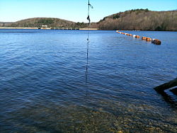
Lake Lillinonah near the Shepaug Dam, April 10, 2010
|
|
| Location | Fairfield and New Haven counties, Connecticut |
| Coordinates | 41°28′08″N 73°18′43″W / 41.469°N 73.312°WCoordinates: 41°28′08″N 73°18′43″W / 41.469°N 73.312°W |
| Type | reservoir |
| Managing agency | Lake Lillinonah Authority, CL&P |
| First flooded | September 27, 1955 |
| Max. length | 12 to 14 miles (19 to 23 km) |
| Surface area | 1,547 to 1,900 acres (626 to 769 ha) |
| Max. depth | 110 feet (34 m) |
| Shore length1 | 45 miles (72 km) |
| References | |
| 1 Shore length is not a well-defined measure. | |
Lake Lillinonah is located in Fairfield and New Haven counties of western Connecticut, in the northeastern United States. It is the second largest lake in Connecticut, smaller only than Candlewood Lake. The lake is bordered by six towns: Brookfield, Bridgewater, Newtown, New Milford, Roxbury, and Southbury. It was formed in 1955 by impoundment of the Housatonic River and the Shepaug River by the Shepaug Dam which was built by the Connecticut Light and Power Company.
...
Wikipedia
