Landkreis St. Wendel
| Sankt Wendel | |
|---|---|
| District | |
 |
|
| Country |
|
| State | Saarland |
| Capital | Sankt Wendel |
| Area | |
| • Total | 476.09 km2 (183.82 sq mi) |
| Population (31 December 2015) | |
| • Total | 88,892 |
| • Density | 190/km2 (480/sq mi) |
| Time zone | CET (UTC+1) |
| • Summer (DST) | CEST (UTC+2) |
| Vehicle registration | WND (since 1957) OE 8/ OE 18/ OE 28 (1949–1956); SA 08 (1945–1949) |
| Website | landkreis-st-wendel.de |
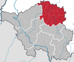
Sankt Wendel is a Kreis (district) in the north of the Saarland, Germany. Neighboring districts are Trier-Saarburg, Birkenfeld, Kusel, Neunkirchen, Saarlouis, and Merzig-Wadern.
The district was created in 1834 when Prussia bought the Lichtenberg area from Saxony-Coburg. After the World War I, the Saar area came under special rulership of the League of Nations, and thus the Sankt Wendel district was split into two parts. The northern part, the Restkreis Sankt Wendel, was merged into the district Birkenfeld, the southern part stayed in the Saarland in its reduced size.
The district is located in the Saar-Hunsrück natural area, a hilly area with elevations between 200 and 600 meters. The main river in the district is the Nahe. The Bostalsee is the biggest tourist lake in the south-west of Germany, covering an area of about 1.2 km².
Coordinates: 49°30′N 7°10′E / 49.5°N 7.17°E
...
Wikipedia
