Las Médulas
| Las Médulas | |
|---|---|
| Name as inscribed on the World Heritage List | |

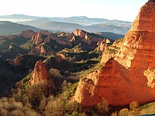
Panoramic view of Las Médulas
|
|
| Type | Cultural |
| Criteria | i, ii, iii, iv |
| Reference | 803 |
| UNESCO region | Europe and North America |
| Coordinates | 42°27′32″N 6°45′36″W / 42.45889°N 6.76000°WCoordinates: 42°27′32″N 6°45′36″W / 42.45889°N 6.76000°W |
| Inscription history | |
| Inscription | 1997 (21st Session) |
Las Médulas (Galician: As Médulas) is an historic mining site near the town of Ponferrada in the region of El Bierzo (province of León, Castile and León, Spain). It was the most important gold mine (and largest open pit gold mine) in the entire Roman Empire. Las Médulas Cultural Landscape is listed by the UNESCO as one of the World Heritage Sites. Advanced aerial surveys conducted in 2014 using LIDAR have confirmed the wide extent of the Roman-era works.
The spectacular landscape of Las Médulas resulted from the ruina montium (wrecking of the mountains), a Roman mining technique described by Pliny the Elder in 77 AD. The technique employed was a type of hydraulic mining which involved undermining a mountain with large quantities of water. The water was supplied by interbasin transfer. At least seven long aqueducts tapped the streams of the La Cabrera district (where the rainfall in the mountains is relatively high) at a range of altitudes. The same aqueducts were used to wash the extensive alluvial gold deposits.
The area Hispania Tarraconensis was conquered in 25 BC by the emperor Augustus. Prior to the Roman conquest the indigenous inhabitants obtained gold from alluvial deposits. Large-scale production did not begin until the second half of the 1st century AD.
Pliny the Elder, who was a procurator in the region in 74 AD, described a technique of hydraulic mining that may be based on direct observation at Las Médulas:
...
Wikipedia

