Lauzerte
| Lauzerte | ||
|---|---|---|

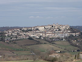
A general view of Lauzerte
|
||
|
||
| Coordinates: 44°15′24″N 1°08′18″E / 44.2567°N 1.1383°ECoordinates: 44°15′24″N 1°08′18″E / 44.2567°N 1.1383°E | ||
| Country | France | |
| Region | Occitanie | |
| Department | Tarn-et-Garonne | |
| Arrondissement | Castelsarrasin | |
| Canton | Lauzerte | |
| Intercommunality | Quercy Pays de Serres | |
| Government | ||
| • Mayor (2008–2014) | Bernard Rey | |
| Area1 | 44.56 km2 (17.20 sq mi) | |
| Population (2012)2 | 1,488 | |
| • Density | 33/km2 (86/sq mi) | |
| Time zone | CET (UTC+1) | |
| • Summer (DST) | CEST (UTC+2) | |
| INSEE/Postal code | 82094 / 82110 | |
| Elevation | 98–270 m (322–886 ft) (avg. 176 m or 577 ft) |
|
|
1 French Land Register data, which excludes lakes, ponds, glaciers > 1 km² (0.386 sq mi or 247 acres) and river estuaries. 2Population without double counting: residents of multiple communes (e.g., students and military personnel) only counted once. |
||
1 French Land Register data, which excludes lakes, ponds, glaciers > 1 km² (0.386 sq mi or 247 acres) and river estuaries.
Lauzerte is a commune in the Tarn-et-Garonne department in the Occitanie region in southern France.
Etymology of the name: Two interpretations include the possible Latin root of “Villaserta” and more likely, the Gallic root, “lauzes”, flat stones used as paving or roofing, and “erta” from the local Occitan dialect, meaning hill, thus Hill of Stones. The fact that the barbican was exploited as a quarry supports this derivation.
A medieval bastide perched above the valleys and hills of the area known as the Quercy Blanc, Lauzerte is one of the Most Beautiful Villages of France, a distinction granted to only 155 villages in the country. Founded in the 12th century by the Count of Toulouse, the village is located on the routes of the Santiago de Compostella. Lauzerte is described by its tourism agency as "a nature stop for family excursions and weekends exploring the rich past and present of the South West: our heritage and architecture, our leisure activities and festivities."
In the northwest corner of the Tarn et Garonne department, Lauzerte lies between the foothills of the Massif Central and the Garonne river plain in the region known as Quercy Blanc and Pays de Serres because of the limestone which predominates in the landscape. The hill town rises above parallel valleys and rivers, the Barguelonnes, the Lendou and the Seoune which feed into the Garonne River.
Lauzerte is surrounded by agricultural land known for Melons de Quercy, Chasselas de Moissac (white dessert grapes), and Pruneaux d’Agen (prunes).
BC: The discovery of copper coins from several years BC indicate that Lauzerte was an oppidum, part of Roman Gaul.
Eleventh century: the area belonged to the Lords of Castelnau Montratier.
At the end of the twelfth century, two local noblemen approached Raymond V, Count of Toulouse, to establish a castelnau, a plot of 200 houses, prefiguring the bastide movement which would later predominate in the region. The motivation to do so would have been the same, however, to establish a small community of rent-paying supporters. With its castle, enclosure, towers and six fortified gateways, the fortified town was the pride of the region. Henry IV, King of France, described it as “one of four keys of the said Quercy land.” Despite this reputation, it was later occupied by the English and suffered attack in the Wars of Religion.
...
Wikipedia


