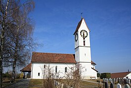
Leutwil
| Leutwil | ||
|---|---|---|
 |
||
|
||
| Coordinates: 47°19′N 8°11′E / 47.317°N 8.183°ECoordinates: 47°19′N 8°11′E / 47.317°N 8.183°E | ||
| Country | Switzerland | |
| Canton | Aargau | |
| District | Kulm | |
| Area | ||
| • Total | 3.75 km2 (1.45 sq mi) | |
| Elevation | 613 m (2,011 ft) | |
| Population (Dec 2015) | ||
| • Total | 756 | |
| • Density | 200/km2 (520/sq mi) | |
| Postal code | 5725 | |
| SFOS number | 4138 | |
| Surrounded by | Birrwil, Boniswil, Dürrenäsch, Hallwil, Zetzwil | |
| Website |
www SFSO statistics |
|
Leutwil is a municipality in the district of Kulm in the canton of Aargau in Switzerland.
Leutwil is first mentioned in 1273 as Lutwile. The rights to high justice in the village in the late 13th and 14th Century was held by the Habsburgs. The rights to low justice was held by the lords of Trostburg, and later those of Reinach and Hallwyl. Between 1415 and 1798 the municipality belonged to the city of Bern as part of the bailiwick of Lenzburg.
The village church was first mentioned in 1273. In the 13th Century, the first frescoes were painted in the church. Additional paintings were added during two periods in the 14th and 15th Centuries. In 1528, the Protestant Reformation entered the village, and the church transitioned to the new religion. In 1616, the Leutwil-Dürrenäsch parish was founded.
There are two monuments that remember the plague epidemic that hit the village in 1629.
In the 18th and 19th Century cotton processing and agriculture provided most of the income to the village. Then, from the late 19th Century until 1990, the major economic activity was the cigar industry. The municipality has bus links to Boniswil, Seengen, Dürrenäsch and Teufenthal.
Leutwil is located in the Kulm district, on a northern spur of the Reinacher Homberg mountain. The municipality consists of the village of Leutwil itself, and the hamlet of Wampfle. While the rest of the municipality is in the Seetal valley, Wampfle is in the Wynental valley.
...
Wikipedia


