Lockhart River, Queensland
|
Lockhart River Queensland |
|||||||
|---|---|---|---|---|---|---|---|

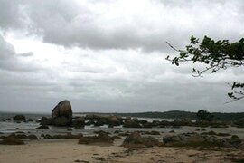
Quintell Beach in Lockhart River
|
|||||||
| Coordinates | 12°47′S 143°21′E / 12.783°S 143.350°ECoordinates: 12°47′S 143°21′E / 12.783°S 143.350°E | ||||||
| Population | 642 (2006 census) | ||||||
| • Density | 0.18110/km2 (0.4690/sq mi) | ||||||
| Postcode(s) | 4871 | ||||||
| Elevation | 17 m (56 ft) | ||||||
| Area | 3,545 km2 (1,368.7 sq mi) | ||||||
| Location | |||||||
| LGA(s) | Lockhart River Aboriginal Shire Council | ||||||
| State electorate(s) | Cook | ||||||
| Federal Division(s) | Leichhardt | ||||||
|
|||||||
Lockhart River is a coastal Aboriginal community situated on the eastern coast of Cape York Peninsula in Queensland, Australia. The population consists mostly of Aboriginal and Torres Strait Islanders, whose ancestors were forcibly moved to the area beginning in 1924. At the 2006 census, Lockhart River had a population of 542, which increased to 642 at the 2011 Census.
It is 800 kilometres (500 mi) north by road from Cairns and approximately 2,550 kilometres (1,580 mi) by road north of Brisbane. Lockhart River is the northernmost town on the east coast of Australia. The community is also located approximately 2 kilometres (1.2 mi) inland from Quintell Beach and is within the Iron Range National Park. During WW2, Lockhart River Airport was constructed as a bomber base, from where many sorties were flown against Japanese forces during the critical Battle of the Coral Sea, 4–8 May 1942.
Lockhart River is also the name of a river located 14 kilometres (8.7 mi) south of the community. The river was named by explorer Robert Logan Jack in January 1880 after a close friend, Hugh Lockhart.
Beginning in 1924, Aboriginal people gathered and were collected from eastern regions of Cape York and placed at the Anglican Church Mission at Orchid Point near the Lockhart River, which had been a centre for the sandalwood trade. Six months later, the Mission was relocated to Bare Hill, south of Cape Direction. After the Second World War broke out, the European superintendent went on furlough in 1942 and the Aboriginal people were told to go to several bush camps and fend for themselves. After 4 to 6 months, the mission was re-established but with poor resources and lack of funding. A better period followed in the 1950s under superintendent John Warby. A Cooperative Society operated during this time while in the trochus shell industry until prices failed. New housing was built and separate group villages were brought together into one on the coastal side.
...
Wikipedia

