Luba, Abra
| Luba | ||
|---|---|---|
| Municipality | ||
|
||
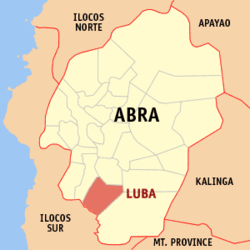
 Map of Abra with Luba highlighted |
||
| Location within the Philippines | ||
| Coordinates: 17°19′N 120°42′E / 17.32°N 120.7°ECoordinates: 17°19′N 120°42′E / 17.32°N 120.7°E | ||
| Country |
|
|
| Region | Cordillera Administrative Region (CAR) | |
| Province | Abra | |
| District | Lone District of Abra | |
| Founded | 1912 | |
| Barangays | 8 (see Barangays) | |
| Government | ||
| • Type | Sangguniang Bayan | |
| • Mayor | Marcus Reimiel A. Biscarra | |
| • Electorate | 4,312 voters (2016) | |
| Area | ||
| • Total | 148.27 km2 (57.25 sq mi) | |
| Population (2015 census) | ||
| • Total | 6,339 | |
| • Density | 43/km2 (110/sq mi) | |
| Time zone | PST (UTC+8) | |
| ZIP code | 2813 | |
| PSGC | 140114000 | |
| IDD : area code | +63 (0)74 | |
| Income class | 5th municipal income class | |
Luba, officially the Municipality of Luba (Ilocano: Ili ti Luba, Filipino: Bayan ng Luba), is a municipality in the province of Abra in the Cordillera Administrative Region (CAR) of the Philippines. The population was 6,339 at the 2015 census. In the 2016 electoral roll, it had 4,312 registered voters.
The earliest known settlement in the municipality of Luba was in Barit. It was then a thickly forested area with tall and big trees interconnected with myriads of rattan vines called barit. The early settlers were hunters as the place was abundant with wild pigs, deer and fruit trees.
The home of fine quality of rattan, Barit increased in population so that another settlement in a nearby place emerged. They called this Barit-Luzong. Southwest of Barit, another settlement occurred and they called this Barit-Lulluno. Barit-Amtuagan soon followed. It is only after a considerable period of time that the settlement of Bancagan (now the capital of the municipality) took place. The old folks has it that the river banks were being avoided due to the presence of a deadly reptiles called buaya. But in the middle part of the 18th century settlement near river banks begun to flourish the old folks surmised that half a century earlier, settlers from the uplands had turn to “slash and burn” farming. A destructive method that almost dissipated the tall and big premium hardwood trees. As a consequence flash flood occurred that resulted to siltation in the deep river bed portion virtually neutralized the hiding place of these buayas. Exposed to attack, their number were kept into a minimum.
The first formal collective name of the municipality of Luba was Barit-Amtuagan, presumably to include all other settlers from the east side of the “kayan” (river). This is located south east of Barit near the Damalin River, the biggest tributary of the Abra river. After sometime, some influential leaders from Barit-Lulluno had caused the transfer of collective capital from Barit-Amtuagan to Barit-Lulluno. For many years, Barit-Lulluno lingered until the onset of the American Regime.
In 1917 or probably earlier, the name of Luba was formally adopted as the official name of the municipality. Accordingly, it was a fusion of the first two letters of Lulluno and Barit.
...
Wikipedia


