Lukuga River
| Lukuga River | |
|---|---|

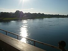
River Lukuga from the bridge in Kalemie
|
|

The Lukuga River, in dark blue
|
|
| Country | Democratic Republic of the Congo |
| Basin features | |
| Main source |
Kalemie 2,800 feet (850 m) |
| River mouth | Lualaba River |
| Basin size | 244,500 square kilometres (94,400 sq mi) |
| Physical characteristics | |
| Length | 320 kilometres (200 mi) |
Coordinates: 5°40′00″S 26°55′00″E / 5.66667°S 26.91667°E
The Lukuga River is a tributary of the Lualaba River in the Democratic Republic of the Congo (DRC) that drains Lake Tanganyika. It is unusual in that its flow varies not just seasonally but also due to longer term climate fluctuations.
The Lukuga runs along the northern edge of the Katanga Plateau. The river leaves Lake Tanganyika at Kalemie and flows through a gap in the highlands westward through the Tanganyika District to join the Lualaba between Kabalo and Kongolo. Typically the river accounts for 18% of water loss from the lake, with the rest being due to evaporation. The Lukuga is heavily mineralized. The proportions of ionic contents where the Lukuga River leaves the lake, with magnesium and potassium more prevalent than calcium and sodium, are caused by the Albertine Rift's hydrothermal inputs seen also at the outlets of Lake Kivu and Lake Edward.
It seems likely that the present hydrological system was extablished quite recently when the still-active Virunga volcanoes erupted and blocked the northward flow of water from Lake Kivu into Lake Edward, causing it instead to discharge southward into Lake Tanganyika through the Ruzizi River. Before that Lake Tanganyika, or separate sub-basins in what is now the lake, may have had no outlet other than evaporation.
...
Wikipedia
