Luzerne Township, Fayette County, Pennsylvania
| Luzerne Township | |
|---|---|
| Township | |

Township municipal building
|
|
 Location of Luzerne Township in Fayette County |
|
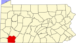
 Location of Fayette County in Pennsylvania |
|
| Country | United States |
| State | Pennsylvania |
| County | Fayette |
| Area | |
| • Total | 30.7 sq mi (79.6 km2) |
| • Land | 29.5 sq mi (76.5 km2) |
| • Water | 1.2 sq mi (3.1 km2) |
| Population (2010) | |
| • Total | 5,965 |
| • Density | 202/sq mi (78.0/km2) |
| Time zone | EST (UTC-4) |
| • Summer (DST) | EDT (UTC-5) |
| Area code(s) | 724 |
Luzerne Township is a township in Fayette County, Pennsylvania, United States. The population was 5,965 at the 2010 census, up from 4,683 at the 2000 census.
The unincorporated communities of East Millsboro, La Belle, Hiller, Isabella, Luzerne, Dutch Hill, Maxwell, Allison, Alicia, East Fredericktown and Penncraft are located within the township. La Belle, Luzerne, Dutch Hill, Maxwell and East Fredericktown are served by the post office in La Belle and thus have the same ZIP code (15450), as does SCI Fayette, a Pennsylvania state prison located next to East Fredericktown.
The Penn-Craft Historic District and Brown-Moore Blacksmith Shop are listed on the National Register of Historic Places.
Luzerne Township is located along the western edge of Fayette County and is bordered to the west by the Monongahela River, which forms the border with Greene and Washington counties. The westernmost point in Fayette County is in Luzerne Township along the Monongahela south of East Millsboro. Dunlap Creek forms the eastern border of the township, flowing north towards the Monongahela at Brownsville, which borders the northeast corner of Luzerne Township.
According to the United States Census Bureau, the township has a total area of 30.7 square miles (79.6 km2), of which 29.5 square miles (76.5 km2) is land and 1.2 square miles (3.1 km2), or 3.92%, is water.
...
Wikipedia
