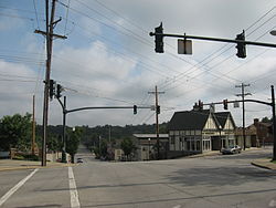
Madeira, Ohio
| Madeira | |
|---|---|
| City | |

Downtown Madeira
|
|
 Location in Hamilton County and the state of Ohio. |
|
| Coordinates: 39°11′18″N 84°22′6″W / 39.18833°N 84.36833°WCoordinates: 39°11′18″N 84°22′6″W / 39.18833°N 84.36833°W | |
| Country | United States |
| State | Ohio |
| County | Hamilton |
| Government | |
| • Mayor | Melisa Adrien (R) |
| Area | |
| • Total | 3.38 sq mi (8.75 km2) |
| • Land | 3.38 sq mi (8.75 km2) |
| • Water | 0 sq mi (0 km2) |
| Elevation | 758 ft (231 m) |
| Population (2010) | |
| • Total | 8,726 |
| • Estimate (2012) | 8,809 |
| • Density | 2,581.7/sq mi (996.8/km2) |
| Time zone | Eastern (EST) (UTC-5) |
| • Summer (DST) | EDT (UTC-4) |
| ZIP code | 45243 |
| Area code(s) | 513 |
| FIPS code | 39-46312 |
| GNIS feature ID | 1061459 |
| Website | www |
Madeira is a city in Hamilton County, Ohio, United States. The population was 8,726 at the 2010 census. Madeira has a Council-Manager form of government, where the elected City Council appoints a paid City Manager to run the day-to-day operations of the city. Madeira is served by its own police department, while fire service is provided by the Madeira-Indian Hill Joint Fire District. Madeira is largely a residential community, with a small downtown and some light industry. Educational needs are served by the nationally ranked Madeira City Schools. Madeira is a suburb of Cincinnati. In 2007, BusinessWeek ranked it as one of the "Best Places to Raise Kids--For Less." Madeira, known for its beautiful parks, has a plethora of sports programs.
Madeira is located at 39°11′18″N 84°22′6″W / 39.18833°N 84.36833°W (39.188310, -84.368366).
According to the United States Census Bureau, the city has a total area of 3.38 square miles (8.75 km2), all land.
It is bordered by:
Madeira was largely laid out in 1871. Before this time the place was known as a post town, and was named for John Madeira who owned a large tract of land in the vicinity.
As of the census of 2010, there were 8,726 people, 3,297 households, and 2,420 families residing in the city. The population density was 2,581.7 inhabitants per square mile (996.8/km2). There were 3,498 housing units at an average density of 1,034.9 per square mile (399.6/km2). The racial makeup of the city was 93.0% White, 2.5% African American, 0.1% Native American, 2.8% Asian, 0.3% from other races, and 1.2% from two or more races. Hispanic or Latino of any race were 2.3% of the population.
...
Wikipedia
