Magdeburger Börde
| Magdeburg Börde | |
|---|---|
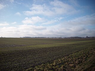
 Farmland near Gutenswegen, Niedere Börde Farmland near Gutenswegen, Niedere Börde
|
|
| Native Name | Magdeburger Börde |
| Area | ca. 949 km² |
| Classification | Handbook of Natural Region Divisions of Germany |
| Level 2 Region | 533, 52, 51, 50, 46, 45, 44 (less 441) → Lößbörden |
| Major unit group | 50 → Middle German Black Earth Region |
| Level 4 Region (major unit) |
504 → Magdeburg Börde |
| County/District | Börde, Salzlandkreis, Magdeburg |
| State(s) | Saxony-Anhalt |
The Magdeburg Börde (German: Magdeburger Börde) is the central landscape unit of the state of Saxony-Anhalt and lies to the west and south of the eponymous state capital Magdeburg. Part of a loess belt stretching along the southeastern rim of the North German Plain, it is noted for its very fertile Chernozem soils.
The boundaries of the Magdeburg Börde are quite ill-defined. In the west, it borders on the East Brunswick hill country stretching from the Hildesheim Börde in Lower Saxony up to the Hohes Holz forest and the town of Oschersleben on the confluence of the Bode river and the Großer Graben canal. According to the recent editions of the Handbook of the Natural Region Divisions of Germany, the western border north of Oschersleben roughly coincides with the Weser-Elbe watershed along the Druxberge hills.
To the northwest, the basin of the Beber river marks the border with the Drömling nature park near Oebisfelde. To the north, the Börde borders on the Altmark (Letzlingen Heath), being also a part of Saxony-Anhalt; the boundary here is generally reckoned to be coincident with the river Ohre and the Mittelland Canal. In any case, the Flechtingen Hills south of the Ohre only partly belong to the Magdeburg Börde.
...
Wikipedia
