Magog River
| Magog River (Rivière Magog) | |
| Sekosonotek | |
|
View of Magog River at the edge of Sherbrooke.
|
|
| Country | Canada |
|---|---|
| Province | Quebec |
| Region | Estrie |
| Tributaries | |
| - left | Red Brook |
| - right | Black Brook, Nick Brook, Dodds Brook |
| Cities | Magog, Quebec, Sherbrooke |
| Source | Lake Memphremagog |
| - location | Magog, Estrie, Quebec, Canada |
| - elevation | 208 m (682 ft) |
| - coordinates | 45°15′43″N 72°9′32″W / 45.26194°N 72.15889°W |
| Mouth | Saint-François River |
| - location | Sherbrooke, Estrie, Quebec, Canada |
| - elevation | 152 m (499 ft) |
| - coordinates | 45°24′20″N 71°53′25″W / 45.40556°N 71.89028°WCoordinates: 45°24′20″N 71°53′25″W / 45.40556°N 71.89028°W |
| Length | 31.8 km (20 mi) |
| Basin | 1,900 km2 (734 sq mi) |
| Discharge | |
| - average | 14.16 m3/s (500 cu ft/s) |
|
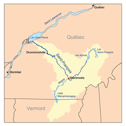
Map of the Saint-François River watershed
|
|
The Magog River is a river that drains Lake Memphremagog. In turn, the river drains into the Saint-François River.
The cities of Sherbrooke and Magog, Quebec, lie on the Magog River.
Engineers from the Université de Sherbrooke have constructed a plastic bridge on the river.
...
Wikipedia


