Manchester (village), Vermont
| Manchester, Vermont | |
|---|---|
| Village | |
| Location within the state of Vermont | |
| Coordinates: 43°9′43″N 73°4′18″W / 43.16194°N 73.07167°WCoordinates: 43°9′43″N 73°4′18″W / 43.16194°N 73.07167°W | |
| Country | United States |
| State | Vermont |
| County | Bennington |
| Area | |
| • Total | 3.58 sq mi (9.26 km2) |
| • Land | 3.54 sq mi (9.18 km2) |
| • Water | 0.03 sq mi (0.08 km2) |
| Elevation | 883 ft (269 m) |
| Population (2010) | |
| • Total | 749 |
| • Density | 211/sq mi (81.6/km2) |
| Time zone | Eastern (EST) (UTC-5) |
| • Summer (DST) | EDT (UTC-4) |
| ZIP code | 05254 |
| Area code(s) | 802 |
| FIPS code | 50-42700 |
| GNIS feature ID | 1461117 |
| Website | villageofmanchester |
|
Manchester Village Historic District
|
|

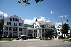
The Equinox Hotel in Manchester
|
|
| Location | US 7A, Union St., and Taconic Ave., Manchester, Vermont |
| Coordinates | 43°9′38″N 73°4′22″W / 43.16056°N 73.07278°W |
| Area | 90 acres (36 ha) |
| Architectural style | Colonial, Federal, Greek Revival |
| NRHP Reference # | 84003438 |
| Added to NRHP | January 26, 1984 |
Manchester is an incorporated village in the town of Manchester, Bennington County, Vermont, United States. The population was 749 at the 2010 census.
The village center, located in the vicinity of Vermont Route 7A, Union Street and Taconic Avenue, was added to the National Register of Historic Places as Manchester Village Historic District in 1984. The district includes 65 contributing and 19 non-contributing properties spread over an area of 90 acres (360,000 m2). The centerpiece of the district is the Equinox House, which is listed separately on the National Register.
Manchester Village was first settled in 1761. Through the middle of the 19th century, Manchester was primarily a crossroads village and the site of several taverns and inns. The village's first inn was built in 1769 on the property that is now the site of the Equinox House. Settlement was slow until after the American Revolutionary War, when the area received an influx of settlers, as Vermont temporarily became the fastest growing U.S. state. In the 19th century, the village was overtaken in economic importance by the growth of Manchester Center, and the village was developed and promoted by Charles F. Orvis (founder of the Orvis mail-order business, still based in Manchester) as a summer resort destination for New Yorkers. The village is one of the first places in New England that was promoted and developed as a summer resort community.
Manchester Village is located on the banks of the Batten Kill in the north-south trending valley between the Green Mountains on the east and the Taconics on the west. Vermont Route 7A runs north-south through the village, and the Batten Kill forms its eastern boundary. According to the United States Census Bureau, the village has a total area of 3.58 square miles (9.26 km2), of which 3.54 square miles (9.18 km2) is land and 0.031 square miles (0.08 km2), or 0.85%, is water.
...
Wikipedia

