Mareth Line
| Mareth Line | |
|---|---|
| Part of French defence of Tunisia | |
| Tunisia | |

Mareth Line in 1943
|
|
| Coordinates | 33°38′00″N 10°18′00″E / 33.63333°N 10.30000°ECoordinates: 33°38′00″N 10°18′00″E / 33.63333°N 10.30000°E |
| Height | 2,200 feet (670 m) |
| Length | 25 miles (40 km) |
| Site information | |
| Owner | French colonial administration of Tunisia |
| Operator | French army |
| Controlled by | German–Italian Panzer Army |
| Condition | Decrepit |
| Site history | |
| Built | 1936 |
| Built by | Le Deuxième Bureau au Travail |
| In use | March 1943 |
| Materials | reinforced concrete |
| Fate | Lapsed into desuetude |
| Battles/wars | Battle of the Mareth Line |
| Garrison information | |
| Past commanders |
Erwin Rommel |
| Garrison | 1943, east to west: 136th Infantry Division Giovani Fascisti, 101st Motorised Division Trieste, 90th Light Division, 80th Infantry Division La Spezia, 16th Motorised Division Pistoia, 164th Light Afrika Division 15th Panzer Division (32 operational tanks) Reserve: 21st Panzer Division, 10th Panzer Division (110 operational tanks) |
| Djebel Tebaga–Djebel Melab: Raggruppamento Sahariano | |
The Mareth Line was a system of fortifications built by France in southern Tunisia, prior to World War II. It was to defend Tunisia against attacks from Libya, then a colony of Fascist Italy. Tunisia was occupied by Axis forces after Operation Torch in 1942 and the line was used by the Axis to defend against the British 8th Army, which had re-occupied Libya during 1943.
French plans for defence of Tunisia assumed that Italy would launch an overwhelming assault that France could not easily oppose. Italy was expected to launch attacks on Egypt and Tunisia as soon as war was declared, with the Italian Navy securing supply and interdicting any substantial Anglo-French relief. With a limited force of six divisions, a fortress division and a cavalry division to defend the French protectorate of Tunisia in French North Africa, the French army settled on the idea of a ligne Maginot du désert (a Maginot Line in the desert). The border with Libya was indefensible for an inferior force, so the French considered two positions inside Tunisia. The best prospect was the Wadi Akarit, which ran from the Chott El Fedjed which is the eastern extension of the Chott el Djerid salt flats, to the Mediterranean Sea. The sea and the salt flats were impassable, so this position could not be flanked but the Wadi Akarit position did not protect the important town and harbour of Gabès. The French colonial government opposed the surrender of so much of Tunisia.
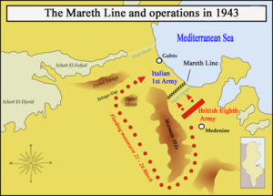
The French chose the next best prospect, along Wadi Zigzaou, between the Matmata Hills and the Mediterranean sea, 37 miles (60 km) south of Wadi Akarit. The banks of Wadi Zigzaou were up to 70 feet (21 m) high and surveys of the Matmata hills indicated they were impassable, with the western desert seeming equally forbidding. This position secured Gabès as a supply base but was easily outflanked to the west, if a mobile force went around the Matmata Hills, and Wadi Zigzaou put the French in front of a bottleneck, vulnerable to air and artillery fire. Construction began in 1936, with the Mareth line laid out in a similar manner to the Maginot line. The fortification stretched for 28 miles (45 km) of fixed defences, trenches and cleared firing blinds. Infantry were to be housed in trenches and forty concrete casements as well as 15 fortified command posts and 28 support posts. The ground did not suit underground artillery but eight large artillery positions were constructed, each capable of accommodating a battery.
...
Wikipedia

