Mariscal Lamar International Airport
|
Mariscal Lamar International Airport Aeropuerto Mariscal Lamar |
|||||||||||
|---|---|---|---|---|---|---|---|---|---|---|---|

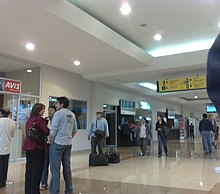
Interior of Mariscal Lamar Airport
|
|||||||||||
| Summary | |||||||||||
| Airport type | Public | ||||||||||
| Operator | Corporación Aeroportuaria de Cuenca | ||||||||||
| Serves | Cuenca, Ecuador | ||||||||||
| Elevation AMSL | 8,306 ft / 2,532 m | ||||||||||
| Coordinates | 02°53′22″S 078°59′04″W / 2.88944°S 78.98444°W | ||||||||||
| Website | |||||||||||
| Map | |||||||||||
| Location of airport in Ecuador | |||||||||||
| Runways | |||||||||||
|
|||||||||||
|
Source: DAFIF
|
|||||||||||
Mariscal Lamar International Airport (Spanish: Aeropuerto Internacional Mariscal Lamar) (IATA: CUE, ICAO: SECU) is an airport serving Cuenca, a city in the province of Azuay in Ecuador.
The airport resides at an elevation of 8,306 feet (2,532 m) above mean sea level. It has one runway designated 05/23 with an asphalt surface measuring 6,234 by 118 feet (1,900 m × 36 m). Since 2002 the ILS system for the airport is available and fully operational. Despite improvements the location of the airport in the middle of the city is a major handicap, as the runway is only barely long enough for large planes landing at this altitude. This has resulted in a few accidents involving planes running off the end of the runway, a restriction on flights in wet weather during much of 2016, and at the end of 2016 the airport completed a resurfacing of the runway to improve traction in wet weather.
...
Wikipedia

