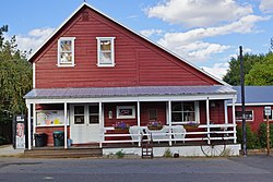
Markleeville, California
| Markleeville | |
|---|---|
| census-designated place | |

General Store
|
|
 Location in Alpine County and the state of California |
|
| Location in the United States | |
| Coordinates: 38°41′42″N 119°46′49″W / 38.69500°N 119.78028°WCoordinates: 38°41′42″N 119°46′49″W / 38.69500°N 119.78028°W | |
| Country |
|
| State |
|
| County | Alpine |
| Government | |
| • State Senate | Ted Gaines (R) |
| • State Assembly | Frank Bigelow (R) |
| • U. S. Congress | (R) |
| Area | |
| • Total | 6.531 sq mi (16.915 km2) |
| • Land | 6.531 sq mi (16.915 km2) |
| • Water | 0 sq mi (0 km2) 0% |
| Elevation | 5,531 ft (1,686 m) |
| Population (2010) | |
| • Total | 210 |
| • Density | 32/sq mi (12/km2) |
| Time zone | Pacific (PST) (UTC-8) |
| • Summer (DST) | PDT (UTC-7) |
| ZIP code | 96120 |
| Area code(s) | 530 |
| FIPS code | 06-45988 |
| GNIS feature IDs | 1659065, 2408184 |
| Marklee's Cabin | |
|---|---|
| Location | Alpine County Courthouse |
| Coordinates | 38°41′41″N 119°46′48″W / 38.694765°N 119.780096°W |
| Built | 1861 |
| Architect | Jacob J. Marklee |
| Reference no. | 240 |
Markleeville (formerly, Markleville) is a census-designated place (CDP) and the county seat of Alpine County, California. The population was 210 at the 2010 census, up from 197 at the 2000 census.
Jacob J. Marklee founded a toll bridge crossing the Carson River in 1861. He aimed to tap into the traffic from the silver mining boom at Silver Mountain City. On June 23, 1862, he recorded a land claim of 160 acres in Douglas County, Nevada. A boundary survey took place, and the property ended up being in California. In 1863, Marklee died after being involved in a gunfight. When the discovery took place, the town of Markleeville was founded on the Marklee property. Today, the Alpine County Courthouse sits on the former property, which is listed as a California Historical Landmark.
A post office opened in Markleeville in 1863.
According to the United States Census Bureau, the CDP has a total area of 6.5 square miles (17 km2), all land. The region comprising Markleeville is Alpine in appearance, with lush grassy valley areas. There is a hot spring, and a state park with a campground. Excellent hiking trails abound.
According to the Köppen Climate Classification system, Markleeville has a warm-summer Mediterranean climate, abbreviated Csb on climate maps, though it approaches a continental Mediterranean climate (Dsb).
Markleeville has warm summers with only occasional rainfall, mostly from afternoon and evening thunderstorms; nights are usually well below 50 °F (10 °C). Winters are somewhat cold and often snowy. The average January temperatures are a maximum of 45.7 °F or 7.6 °C and a minimum of 17.4 °F or −8.1 °C. The average July temperatures are a maximum of 84.5 °F (29.2 °C) and a minimum of 43.1 °F or 6.2 °C. There are an average of 15.7 afternoons with highs of 90 °F or 32.2 °C or higher and an average of 221.7 mornings with lows of 32 °F or 0 °C or lower, including 5.4 mornings falling to or below 0 °F or −17.8 °C, and 8.1 afternoons that do not top freezing. The record high temperature was 102 °F (38.9 °C) on July 11, 1931. The record low temperature was −25 °F (−31.7 °C) on December 22, 1990.
...
Wikipedia

