Maui, Hawaii
| Nickname: The Valley Isle | |
|---|---|

Landsat satellite image of Maui. The small island to the southwest is Kahoʻolawe.
|
|
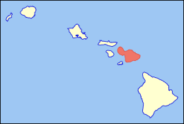
| Location in the state of Hawaii. | |
| Geography | |
| Location | 20°48′N 156°20′W / 20.800°N 156.333°W |
| Area | 727.2 sq mi (1,883 km2) |
| Area rank | 2nd largest Hawaiian Island |
| Highest elevation | 10,023 ft (3,055 m) |
| Highest point | Haleakalā |
| Administration | |
|
United States
|
|
| Symbols | |
| Flower | Lokelani |
| Color | ʻĀkala (pink) |
| Demographics | |
| Population | 154,834 (2015-16) |
| Pop. density | 162 /sq mi (62.5 /km2) |
The island of Maui (/ˈmaʊ.iː/; Hawaiian: [ˈmɐwwi]) is the second-largest of the Hawaiian Islands at 727.2 square miles (1,883 km2) and is the 17th-largest island in the United States. Maui is part of the State of Hawaii and is the largest of Maui County's four islands, bigger than Molokaʻi, Lānaʻi, and unpopulated Kahoʻolawe. In 2010, Maui had a population of 144,444, third-highest of the Hawaiian Islands, behind that of Oʻahu and Hawaiʻi Island. Kahului is the largest census-designated place (CDP) on the island with a population of 26,337 as of 2010[update] and is the commercial and financial hub of the island.Wailuku is the seat of Maui County and is the third-largest CDP as of 2010[update]. Other significant places include Kīhei (including Wailea and Makena in the Kihei Town CDP, which is the second-most-populated CDP in Maui), Lahaina (including Kāʻanapali and Kapalua in the Lahaina Town CDP), Makawao, Pāʻia, Kula, Haʻikū, and Hāna.
...
Wikipedia

