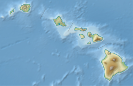
Mauna Kea, Hawaii
| Mauna Kea | |
|---|---|
| Maunakea | |

Mauna Kea in December 2007, with its seasonal snow cap visible
|
|
| Highest point | |
| Elevation | 4,207.3 m (13,803 ft) |
| Prominence | 4,207.2 m (13,803 ft) |
| Isolation | 3,947 km (2,453 mi) |
| Listing | |
| Coordinates | 19°49′14″N 155°28′05″W / 19.820664075°N 155.468066397°WCoordinates: 19°49′14″N 155°28′05″W / 19.820664075°N 155.468066397°W |
| Geography | |
| Location | Hawaii County, Hawaii, United States |
| Parent range | Hawaiian Islands |
| Geology | |
| Age of rock | Oldest dated rock: 237,000 ± 31,000 BP Approximate: ~1 million |
| Mountain type |
Shield volcano Hotspot volcano |
| Volcanic arc/belt | Hawaiian–Emperor seamount chain |
| Last eruption | 2460 BC ± 100 years |
| Climbing | |
| First ascent | Recorded: Goodrich (1823) |
| Easiest route | Mauna Kea Trail |
| Designated | November 1972 |
Mauna Kea (/ˌmɔːnə ˈkeɪ.ən/ or /ˌmaʊnə ˈkeɪ.ə/, Hawaiian: [ˈmɐwnə ˈkɛjə]), is a dormant volcano on the island of Hawaii. Standing 4,207 m (13,802 ft) above sea level, its peak is the highest point in the state of Hawaii. Much of the mountain is under water; when measured from its oceanic base, Mauna Kea is over 10,000 m (33,000 ft) tall and is the tallest mountain on Earth. Mauna Kea is about a million years old, and has thus passed the most active shield stage of life hundreds of thousands of years ago. In its current post-shield state, its lava is more viscous, resulting in a steeper profile. Late volcanism has also given it a much rougher appearance than its neighboring volcanoes; contributing factors include the construction of cinder cones, the decentralization of its rift zones, the glaciation on its peak, and the weathering effects of the prevailing trade winds. Mauna Kea last erupted 6,000 to 4,000 years ago and is now considered dormant.
...
Wikipedia

