McKean Township, Erie County, Pennsylvania
| McKean Township | |
| Township | |
| Country | United States |
|---|---|
| State | Pennsylvania |
| County | Erie |
| Coordinates | 41°58′0″N 80°4′59″W / 41.96667°N 80.08306°WCoordinates: 41°58′0″N 80°4′59″W / 41.96667°N 80.08306°W |
| Area | 36.9 sq mi (96 km2) |
| - land | 36.8 sq mi (95 km2) |
| - water | 0.2 sq mi (1 km2) |
| Population | 4,409 (2010) |
| Density | 119.8/sq mi (46/km2) |
| Settled | 1795 |
| - Incoroporated | March 12, 1800 |
| Timezone | EST (UTC-4) |
| - summer (DST) | EDT (UTC-5) |
| Area code | 814 |
|
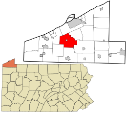
Location in Erie County and the state of Pennsylvania.
|
|
|
Website: www |
|
McKean Township is a township in Erie County, Pennsylvania, United States. The population was 4,409 at the 2010 census, down from 4,619 at the 2000 census.
The township is in the central part of Erie County and surrounds the borough of McKean, a separate municipality. According to the United States Census Bureau, the township has a total area of 36.9 square miles (95.7 km2), of which 36.8 square miles (95.3 km2) is land and 0.15 square miles (0.4 km2), or 0.41%, is water. The principal streams are Elk Creek, which flows west into Lake Erie, and its tributary Lamson Run.
Interstate 79 and Interstate 90 intersect in the northeast corner of the township. The interchange is 8 miles (13 km) south of downtown Erie, 96 miles (154 km) southwest of Buffalo, New York, 119 miles (192 km) north of Pittsburgh, and 93 miles (150 km) northeast of Cleveland, Ohio.
McKean Township is located in the Lake Erie Snowbelt and receives significant amounts of lake effect snow every winter.
As of the census of 2000, there were 4,619 people, 1,649 households, and 1,322 families residing in the township. The population density was 126.2 people per square mile (48.7/km²). There were 1,714 housing units at an average density of 46.8/sq mi (18.1/km²). The racial makeup of the township was 98.20% White, 0.56% African American, 0.39% Native American, 0.11% Asian, 0.28% from other races, and 0.45% from two or more races. Hispanic or Latino of any race were 0.71% of the population.
...
Wikipedia

