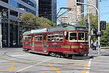
Melbourne tram route 35
| City Circle (Route 35) | |||||
|---|---|---|---|---|---|
 |
|||||

|
|||||
| Overview | |||||
| System | Melbourne tramway network | ||||
| Operator | Yarra Trams | ||||
| Depot | Southbank | ||||
| Vehicle | W class | ||||
| Began service | 29 April 1994 | ||||
| Route | |||||
| Locale | Melbourne, Australia | ||||
| Service | |||||
| Journey time | 55 minutes | ||||
| Operates | Daily | ||||
| Zone(s) | Free Tram Zone | ||||
| Timetable | City Circle timetable | ||||
| Map | City Circle map | ||||
|
|||||
The City Circle is a zero-fare tram running around the Melbourne City Centre in Australia. Aimed mainly at tourists, the route passes many Melbourne attractions while running along the city centre's outermost thoroughfares, as well as the developing Docklands waterfront precinct. It operates in both clockwise and anti-clockwise direction.
The tram route was introduced on 29 April 1994, requiring a small track extension along Spring Street, between Collins and Flinders Streets, to enable a complete CBD loop to be formed. The Federal Government's Building Better Cities program funded the $6.4 million capital cost of the track expansion, while the State Government funded the running costs.
Until January 2003 the western leg of the original route of the tram was down Spencer Street, but the route was then extended west to run through Docklands. The travel time around the circle before this change was 40 minutes.
During early 2006, new Passenger Information Displays were installed along with Digital Voice Announcements.
In April 2008, the service adopted the daylight saving timetable on a permanent basis, operating from 10:00 to 21:00 every Thursday, Friday and Saturday. The end of service at other times is 18:00.
...
Wikipedia

