Mercerville-Hamilton Square, New Jersey
| Mercerville-Hamilton Square, New Jersey | |
|---|---|
| Former census-designated place | |
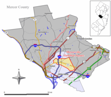
 Map of the former Mercerville-Hamilton Square CDP in Mercer County. Inset: Location of Mercer County in New Jersey. |
|
| Coordinates: 40°13′52″N 74°40′31″W / 40.23111°N 74.67528°WCoordinates: 40°13′52″N 74°40′31″W / 40.23111°N 74.67528°W | |
| Country |
|
| State |
|
| County | Mercer |
| Township | Hamilton |
| Area | |
| • Total | 20.0 km2 (7.7 sq mi) |
| • Land | 20.0 km2 (7.7 sq mi) |
| • Water | 0.0 km2 (0.0 sq mi) |
| Population (2000 Census) | |
| • Total | 26,419 |
| • Density | 1,323.8/km2 (3,428.6/sq mi) |
| Time zone | Eastern (EST) (UTC-5) |
| • Summer (DST) | Eastern (EDT) (UTC-4) |
| FIPS code | 3445495 |
Mercerville-Hamilton Square is a census-designated place and unincorporated community located within Hamilton Township, in Mercer County, New Jersey, United States. As of the 2000 United States Census, the CDP's population was 26,419. As part of the 2010 Census, the area was split into two CDPs, Mercerville and Hamilton Square.
There are a number of historical markers in Mercerville, many detailing the path of the Continental Army under the command of George Washington through the area during the American Revolutionary War, especially related to the night march from the Second Battle of Trenton to the Battle of Princeton.
Originally called "Sandtown," Mercerville is named after General Hugh Mercer who died on January 12, 1777 due to wounds incurred at the Battle of Princeton. Hamilton Square was named after Alexander Hamilton in a wave of anti-British sentiment at the time of the War of 1812. It previously had been called Nottingham after the British town.
According to the United States Census Bureau, the Mercerville-Hamilton Square CDP had a total area of 20.0 km2 (7.7 mi2), all of it land.
...
Wikipedia
