Milford (CT)
| Milford, Connecticut | |||
|---|---|---|---|
| City | |||

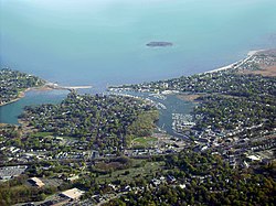
Aerial view of Milford city center and harbor
|
|||
|
|||
| Etymology: Ford by a mill | |||
| Nickname(s): Sleepy Hollow | |||
| Motto: A Small City with a Big Heart! | |||
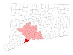
 Location in New Haven County, Connecticut |
|||
| Coordinates: 41°13′27″N 73°03′35″W / 41.22417°N 73.05972°WCoordinates: 41°13′27″N 73°03′35″W / 41.22417°N 73.05972°W | |||
| Country |
|
||
| U.S. state |
|
||
| County | New Haven | ||
| Region | Coastal Connecticut | ||
| Settled | 1639 | ||
| Incorporated (city) | 1959 | ||
| Government | |||
| • Type | Mayor–Board of Aldermen | ||
| • Mayor | Benjamin G. Blake (D) | ||
| Area | |||
| • Total | 26.13 sq mi (67.7 km2) | ||
| • Land | 21.90 sq mi (56.7 km2) | ||
| • Water | 3.23 sq mi (8.4 km2) | ||
| Population (2010) | |||
| • Total | 51,271 | ||
| • Density | 2,341/sq mi (904/km2) | ||
| United States Census 2010, United States Census Bureau | |||
| Time zone | Eastern (UTC-5) | ||
| • Summer (DST) | Eastern (UTC-4) | ||
| ZIP code | 06460, 06461 | ||
| Area code(s) | 203/475 | ||
| FIPS code | 09-47515 | ||
| GNIS feature ID | 0208882 | ||
| Website | www |
||
Milford is a Coterminous municipality within Coastal Connecticut and New Haven County, Connecticut, between Bridgeport, Connecticut and New Haven, Connecticut. The population was 51,271 at the 2010 census. The city includes the borough of Woodmont and the village of Devon. Milford is part of the New York-Newark, NY-NJ-CT-PA Combined Statistical Area.
The land which today comprises Milford, Orange and West Haven was purchased on February 1, 1639 from Ansantawae, chief of the local Paugussets (an Algonquian tribe) by English settlers affiliated with the contemporary New Haven Colony. Originally, the area was known as "Wepawaug", after the small river which runs through the town, and which has given its name to several streets in both Milford and Orange.
A grist mill was first built over the Wepawaug River in 1640.
During the Revolutionary War the Milford section of the Boston Post Road, a vital route connecting Boston, New York and other major coastal cities, was blockaded by Continental forces, and Fort Trumbull was constructed to protect the town. The site of the blockade is commemorated by the Liberty Rock monument.
...
Wikipedia


