Milledgeville, Georgia
| Milledgeville, Georgia | |
|---|---|
| City | |

|
|
| Motto: "Capitols, Columns & Culture" | |
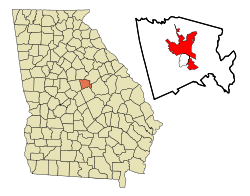
 Location in Baldwin County and the state of Georgia |
|
| Coordinates: 33°5′16″N 83°14′0″W / 33.08778°N 83.23333°WCoordinates: 33°5′16″N 83°14′0″W / 33.08778°N 83.23333°W | |
| Country | United States |
| State | Georgia |
| County | Baldwin |
| Government | |
| • Mayor | Gary Thrower |
| Area | |
| • Total | 20.6 sq mi (53.3 km2) |
| • Land | 20.4 sq mi (52.9 km2) |
| • Water | 0.2 sq mi (0.4 km2) |
| Elevation | 330 ft (100 m) |
| Population (2010) | |
| • Total | 18,382 |
| • Density | 901/sq mi (347.8/km2) |
| Time zone | Eastern Time (UTC-5) |
| • Summer (DST) | EDT (UTC-4) |
| ZIP codes | 31061 |
| Area code(s) | 478 |
| FIPS code | 13-51492 |
| GNIS feature ID | 0332390 |
| Website | www |
Milledgeville is a city in and the county seat of Baldwin County in the U.S. state of Georgia. It is northeast of Macon and bordered on the east by the Oconee River. The rapid current of the river here made this an attractive location to build a city. It was the capital of Georgia from 1804 to 1868, notably during the American Civil War. Milledgeville was preceded as the capital city by Louisville and was succeeded by Atlanta, the current capital. Today U.S. Highway 441 connects Milledgeville to Madison, Athens, and Dublin.
The population of the town of Milledgeville was 18,382 at the 2010 census.
Milledgeville is along the route of the Fall Line Freeway, which is under construction to link Milledgeville with Augusta, Macon, Columbus, and other Fall Line cities. They have long histories from the colonial era of Georgia.
Milledgeville is the principal city of the Milledgeville Micropolitan Statistical Area, a micropolitan area that includes Baldwin and Hancock counties. It had a combined population of 54,776 at the 2000 census. The Old State Capitol is located in the city.
...
Wikipedia
