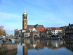
Minderbroederklooster
|
Roermond Remunj |
|||
|---|---|---|---|
| Town and municipality | |||

Roermond in 2011
|
|||
|
|||
 Location in Limburg |
|||
| Coordinates: 51°12′N 5°59′E / 51.200°N 5.983°ECoordinates: 51°12′N 5°59′E / 51.200°N 5.983°E | |||
| Country | Netherlands | ||
| Province | Limburg | ||
| Government | |||
| • Body | Municipal council | ||
| • Mayor | Rianne Donders-de Leest (CDA) | ||
| Area | |||
| • Total | 71.10 km2 (27.45 sq mi) | ||
| • Land | 60.84 km2 (23.49 sq mi) | ||
| • Water | 10.26 km2 (3.96 sq mi) | ||
| Elevation | 22 m (72 ft) | ||
| Population (August 2017) | |||
| • Total | 57,686 | ||
| • Density | 948/km2 (2,460/sq mi) | ||
| Demonym(s) | Roermondenaar | ||
| Time zone | CET (UTC+1) | ||
| • Summer (DST) | CEST (UTC+2) | ||
| Postcode | 6040–6049, 6070–6071 | ||
| Area code | 0475 | ||
| Website | www |
||
Roermond (Dutch pronunciation: [ruːrˈmɔnt] (![]() listen); Limburgish: Remunj) is a city, a municipality, and a diocese in the southeastern part of the Netherlands.
listen); Limburgish: Remunj) is a city, a municipality, and a diocese in the southeastern part of the Netherlands.
Roermond is an historically important town, on the lower Roer at the east bank of the Meuse river. It received town rights in 1231. Roermond town centre has been designated as a conservation area.
Through the centuries the town has filled the role of commercial centre, principal town in the duchy of Guelders and since 1559 it has served as the seat of the Roman Catholic Diocese of Roermond. The skyline of the historic town is dominated by the towers of its two churches: St. Christopher Cathedral and Roermond Minster or 'Munsterkerk' in Dutch. In addition to important churches, the town centre has many listed buildings and monuments.
Where before Celtic inhabitants of this region used to live on both sides of the Roer river, invading Romans built a bridge (now called the Steene Brök, or stone bridge) and founded the first town at Roermond, now a suburb called Voorstad Sint Jacob.
...
Wikipedia


