Misilyah
| Misilyah | |
|---|---|
| Other transcription(s) | |
| • Arabic | مسلية |
 |
|
| Location of Misilyah within the Palestinian territories | |
| Coordinates: 32°23′12″N 35°17′17″E / 32.38667°N 35.28806°ECoordinates: 32°23′12″N 35°17′17″E / 32.38667°N 35.28806°E | |
| Palestine grid | 177/199 |
| Governorate | Jenin |
| Government | |
| • Type | Village council |
| Population (2006) | |
| • Jurisdiction | 2,252 |
| Name meaning | 'an example', In Phænician: 'an image', in old Arabic it means: 'traces of a dwelling which are becoming effaced' |
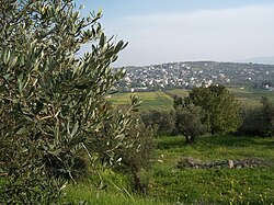
Misilyah (Arabic: مسلية) is a Palestinian village in the northern West Bank, located 14 kilometers south of the city of Jenin. According to the Palestinian Central Bureau of Statistics, the village had a population of 2,252 inhabitants in mid-year 2006. The main agricultural crops cultivated in Misilya are olives, grapes, figs, and vegetables. Roman and Islamic ruins have been found in the village.
C. R. Conder suggested that Misilyah was ancient Bethulia.
In 1838, Edward Robinson noted the village when he travelled in the region, as bordering the extremely fertile Marj Sanur. He listed it as part of the District of Haritheh, north of Nablus.
In 1870, Victor Guérin noted it, "sitting on the northern slopes of a hill planted with superb olive trees; at the bottom there is a fertile and well-cultivated plain."
In 1882, the Palestine Exploration Fund's Survey of Western Palestine described Meselieh: "A small village, with a detached portion to the north, and placed on a slope, with a hill to the south, and surrounded by good olive-groves, with an open valley called Wady el Melek (' the King's Valley') on the north. The water-supply is from wells, some of which have an ancient appearance. They are mainly supplied with rain-water."
In the 1922 census of Palestine conducted by the British Mandate authorities, Meselayyeh had a population 190 Muslims, increasing in the 1931 census to 222 Muslim, in a total of 49 houses.
In 1945 the population was 330 Muslims, with a total of 9,038 dunams of land, according to an official land and population survey. Of this, 2,683 dunams were used for plantations and irrigable land, 2,592 dunams were for cereals, while a total of 23 dunams were built-up, urban land.
...
Wikipedia

