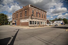
Morristown, Indiana
| Morristown, Indiana | |
|---|---|
| Town | |
 |
|
 Location of Morristown in Shelby County, Indiana. |
|
| Coordinates: 39°40′25″N 85°41′49″W / 39.67361°N 85.69694°WCoordinates: 39°40′25″N 85°41′49″W / 39.67361°N 85.69694°W | |
| Country | United States |
| State | Indiana |
| County | Shelby |
| Township | Hanover |
| Area | |
| • Total | 2.51 sq mi (6.51 km2) |
| • Land | 2.50 sq mi (6.46 km2) |
| • Water | 0.02 sq mi (0.04 km2) |
| Elevation | 833 ft (254 m) |
| Population (2010) | |
| • Total | 1,218 |
| • Estimate (2016) | 1,340 |
| • Density | 537.07/sq mi (207.34/km2) |
| Time zone | Eastern (EST) (UTC-5) |
| • Summer (DST) | EDT (UTC-4) |
| ZIP code | 46161 |
| Area code(s) | 765 |
| FIPS code | 18-51192 |
| GNIS feature ID | 439467 |
| Website | http://www.morristown.in.gov/ |
Morristown is a town in Hanover Township, Shelby County, in the U.S. state of Indiana. The population was 1,218 at the 2010 census.
Morristown was platted in 1828 by Samuel Morrison, and named for him. The Morristown post office has been in operation since 1834.
Junction Railroad Depot was listed on the National Register of Historic Places in 1979.
Morristown is located at 39°40′25″N 85°41′49″W / 39.67361°N 85.69694°W (39.673478, -85.696871).
According to the 2010 census, Morristown has a total area of 2.37 square miles (6.14 km2), of which 2.35 square miles (6.09 km2) (or 99.16%) is land and 0.02 square miles (0.05 km2) (or 0.84%) is water.
As of the census of 2010, there were 1,218 people, 467 households, and 311 families residing in the town. The population density was 518.3 inhabitants per square mile (200.1/km2). There were 519 housing units at an average density of 220.9 per square mile (85.3/km2). The racial makeup of the town was 98.6% White, 0.1% African American, 0.7% Native American, 0.1% Asian, and 0.6% from two or more races. Hispanic or Latino of any race were 1.3% of the population.
...
Wikipedia
