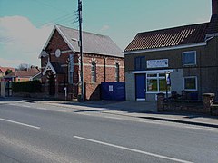
Morton-on-Swale
| Morton-on-Swale | |
|---|---|
 Morton-on-Swale |
|
| Morton-on-Swale shown within North Yorkshire | |
| Population | 536 (2011) |
| OS grid reference | SE327920 |
| District | |
| Shire county | |
| Region | |
| Country | England |
| Sovereign state | United Kingdom |
| Post town | NORTHALLERTON |
| Postcode district | DL7 9 |
| Police | North Yorkshire |
| Fire | North Yorkshire |
| Ambulance | Yorkshire |
| EU Parliament | Yorkshire and the Humber |
| UK Parliament | |
Morton-on-Swale is a large village and civil parish in the Hambleton district of North Yorkshire, England. It lies on the A684 road about 4 miles west of the County Town of Northallerton. It is less than 1 mile (1.6 km) to the village of Ainderby Steeple. As the name suggests it lies on the River Swale.
The village is mentioned twice in the Domesday Book as Moretun. At the time of the Norman invasion, the lands were part of the manor of Kirkby Fleetham held by Gospatric, son of Arnketil, with some lands held by Grim. Afterwards the descent of the manor followed that of nearby Ainderby Steeple.
The topynomy of the village is derived from the Old English word mōr for Moor and the word tun for farm, with the addition of the geographical reference to the nearby river, giving Moor farm on the River Swale.
The village lies within the Richmond UK Parliament constituency. It also lies within the Swale electoral division of North Yorkshire County Council and the Morton-on-Swale ward of Hambleton District Council. An electoral ward in the same name exists. This ward stretches north to Danby Wiske with a total population taken at the 2011 Census of 1,761.
The parish boundary is formed by the River Swale on the west and River Wiske on the east and south. The northern boundary runs just south of Thrintoft. The neighbouring parishes consist of Ainderby Steeple, Thrintoft, Scruton, Leeming, Gatenby, Maunby, Newby Wiske and Warlaby. The village lies on the A684 road between Northallerton and Bedale. The villages of Ainderby Steeple and Thrintoft are within a mile of the village. The highest point in the village is 131 feet (40 m) at the recreation ground.
...
Wikipedia

