Mount Adam (Antarctica)
| Admiralty Mountains | |
|---|---|

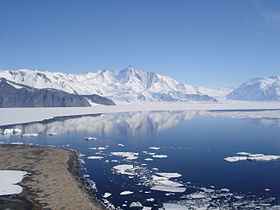
Mount Herschel (3,335 m) in the Admiralty Mountains as seen from Cape Hallett
|
|
| Highest point | |
| Peak | Mount Minto |
| Elevation | 4,165 m (13,665 ft) |
| Coordinates | 71°47′S 168°45′E / 71.783°S 168.750°E |
| Geography | |
| Continent | Antarctica |
| State/Province | Victoria Land |
| Range coordinates | 71°45′S 168°30′E / 71.750°S 168.500°ECoordinates: 71°45′S 168°30′E / 71.750°S 168.500°E |
| Parent range | Transantarctic Mountains |
The Admiralty Mountains (alternatively Admiralty Range) is a large group of high mountains and individually named ranges and ridges in northeastern Victoria Land, Antarctica. This mountain group is bounded by the Ross Sea, the Southern Ocean, and by the Dennistoun, Ebbe, and Tucker glaciers. The mountain range is situated on the Pennell Coast, a portion of Antarctica lying between Cape Williams and Cape Adare.
It was discovered in January 1841 by Captain James Ross, who named them for the Lords Commissioners of the Admiralty under whose orders he served.
The Admiralty Mountains are divided into the Dunedin Range, Homerun Range, and Lyttelton Range.
This range includes the following mountains and peaks:
Mount Achilles is a prominent pyramidal mountain rising from the divide between Fitch Glacier and Man-o-War Glacier. Named by New Zealand Geological Survey Antarctic Expedition (NZGSAE), 1957–58, after the former New Zealand cruiser HMNZS Achilles.
Mount Adam is situated 4 km (2.5 mi) WNW of Mount Minto. Discovered in January 1841 by Captain Ross who named this feature for Vice Admiral Sir Charles Adam, a senior naval lord of the Admiralty.
...
Wikipedia
