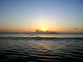
Mulambin, Queensland
|
Mulambin Queensland |
|||||||||||||||
|---|---|---|---|---|---|---|---|---|---|---|---|---|---|---|---|

Sunrise from Mulambin Beach looking out towards Great Keppel Island, 2012
|
|||||||||||||||
| Coordinates | 23°11′52″S 150°47′19″E / 23.1978°S 150.7885°ECoordinates: 23°11′52″S 150°47′19″E / 23.1978°S 150.7885°E | ||||||||||||||
| Postcode(s) | 4703 | ||||||||||||||
| LGA(s) | Shire of Livingstone | ||||||||||||||
| State electorate(s) | Keppel | ||||||||||||||
| Federal Division(s) | Capricornia | ||||||||||||||
|
|||||||||||||||
Mulambin is a town and a locality on the Capricorn Coast in the Shire of Livingstone, Queensland, Australia.
The eastern boundary of Mulambin is the beach beach fronting onto the Coral Sea. The Scenic Highway runs from the north to the south as an esplanade between the beach and the residential area.The western boundary is Mulambin Creek which flows from the north to the south into Causeway Lake. The western part of the locality is largely undeveloped freehold land.
...
Wikipedia

