Multnomah Channel
| Multnomah Channel | |
| Distributary | |
|
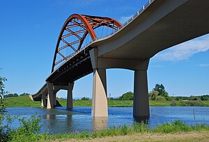
Passing under the Sauvie Island Bridge
|
|
| Country | United States |
|---|---|
| State | Oregon |
| County | Multnomah and Columbia |
| Source | Willamette River |
| - location | Portland, Multnomah County |
| - elevation | 19 ft (6 m) |
| - coordinates | 45°37′08″N 122°47′47″W / 45.61889°N 122.79639°W |
| Mouth | Columbia River |
| - location | St. Helens, Columbia County |
| - elevation | 8 ft (2 m) |
| - coordinates | 45°51′30″N 122°47′36″W / 45.85833°N 122.79333°WCoordinates: 45°51′30″N 122°47′36″W / 45.85833°N 122.79333°W |
| Length | 21.5 mi (35 km) |
The Multnomah Channel is a 21.5-mile (34.6 km) distributary of the Willamette River. It diverges from the main stem a few miles upstream of the main stem's confluence with the Columbia River in Multnomah County in the U.S. state of Oregon. The channel flows northwest then north around Sauvie Island to meet the Columbia River near the city of St. Helens, in Columbia County.
Chinook people, the Multnomahs, lived in villages along the channel at the time of European exploration of the Columbia River in the late 18th and early 19th centuries. Flanked in the 21st century by moorages, marinas, and parks, and populated by a wide variety of fish, the channel offers many opportunities for recreation.
Constrained by dikes, the channel is about one-third as wide as the lower Willamette main stem.U.S. Route 30 and tracks of the Burlington Northern Railroad run roughly parallel to the channel, and to its , between its source and the Multnomah–Columbia county border at about the channel's river mile (RM) 12.5 or river kilometer (RK) 20.1.
In its first 0.5 miles (0.80 km), the channel receives Miller Creek from the left, then passes under Sauvie Island Bridge, which carries Northwest Sauvie Island Road. Below the bridge, Ennis Creek enters from the left, then McCarthy Creek from the left at RM 18 (RK 29). Further along, Johns Creek enters from the left, and then Joy Creek enters from the left where the channel leaves Multnomah County and enters Columbia County. About 8 miles (13 km) from the mouth, the channel flows around Coon Island. Shortly thereafter, Crane Slough, which drains Crane's Lake, and the Gilbert River, which drains Sturgeon Lake, enter from the right. Then the channel receives Jackson Creek from the left and Cunningham Slough from the right before flowing around Louse Island and merging with Scappoose Bay, which is on the left. St. Helens is on the left as the channel enters the Columbia, about 86.5 miles (139.2 km) from the larger stream's mouth on the Pacific Ocean.
...
Wikipedia


