NC 211
| North Carolina Highway 211 | ||||
|---|---|---|---|---|

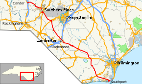
Route of NC 211 highlighted in red
|
||||
| Route information | ||||
| Maintained by NCDOT | ||||
| Length: | 162.5 mi (261.5 km) | |||
| Existed: | 1921 – present | |||
| Major junctions | ||||
| South end: |
|
|||
|
|
||||
| North end: |
|
|||
| Location | ||||
| Counties: | New Hanover, Brunswick, Columbus, Bladen, Robeson, Hoke, Moore, Montgomery | |||
| Highway system | ||||
|
||||
| North Carolina Highway 211A | |
|---|---|
| Location: | Lumberton, North Carolina |
| Length: | 0.30 mi (0.48 km) |
| Existed: | 1949–1957 |
| North Carolina Highway 211A | |
|---|---|
| Location: | Lumberton, North Carolina |
| Length: | 3.4 mi (5.5 km) |
| Existed: | 1957–1960 |
|
North Carolina Highway 211 Business |
|
|---|---|
| Location: | Lumberton, North Carolina |
| Length: | 3.4 mi (5.5 km) |
| Existed: | 1960–1971 |
|
North Carolina Highway 211 Business |
|
|---|---|
| Location: | Bladenboro, North Carolina |
| Length: | 5.7 mi (9.2 km) |
| Existed: | 1975–present |
North Carolina Highway 211 (NC 211) is a primary state highway in the U.S. state of North Carolina. It traverses mostly through the Sandhills and Coastal Plain regions of the state; connecting the cities of Candor, Aberdeen, Raeford, Lumberton, Bladenboro, and Southport.
NC 211 is predominantly a two-lane rural highway that traverses for 158.4 miles (254.9 km) in a diagonal northwesterly route. Its southern terminus is at US 421, via the Fort Fisher Ferry Terminal, in Fort Fisher. Crossing the Cape Fear River on the Fisher-Southport Ferry, travelers enter the town of Southport; where the highway first goes through the downtown area before begins its northwesterly direction to Supply, where it connects with US 17.
...
Wikipedia

